
Sacred Texts Legends and Sagas England Index Previous Next
Stonehenge and Other British Stone Monuments Astronomically Considered, by Norman Lockyer, [1906], at sacred-texts.com
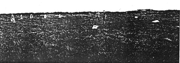
THERE are two circles situated on Truthwall Common near to Tregaseal and not far from St. Just; the one is nearly to the east of the other, and there are outstanding stones, including four holed stones, and several barrows. The eastern temple has a diameter of 69 feet, and includes, at the present time, nine erect and four prostrate; stones; the original structure seems to have contained twenty-eight stones according to Lukis.
My wife and I visited the region in January, 1906, but previously to our going Mr. Horton Bolitho, accompanied by Mr. Thomas, whose knowledge of the local antiquities is very great, had explored the region and taught us what to observe.
The chief interest appears to lie on the N.E. quadrant, where, in addition to a famous longstone on a hill about a mile away, the nest of holed stones and several of the barrows are located. Carn Kenidjack, a famous landmark, lies to the north.
Of the two circles, I confined my attention almost exclusively to the eastern one, as the other is in a
fragmentary condition, though it is still traceable. It is hidden almost entirely from the eastern circle by a modern hedge.
Mr. Horton Bolitho, who accompanied us in January, has again visited the spot, with Mr. Thomas, for the purpose of further exploration, and determining the angular height of the sky-line along the different alignments, which I have plotted from the 6-inch and 25-inch maps. My readers will therefore see that my part of the work has been a small one, and that they are chiefly indebted to those I have named.
No theodolite survey has as yet been made for determining the azimuths and the height of the hills. The following approximate azimuths have been determined by myself from a 25-inch map, and the elevations by Mr. Horton Bolitho by means of a miner's dial.
|
Alignments. |
Azimuth. |
Elevation. | ||
|
1. Apex of Carn |
N. 12° |
8´ E. |
4° |
0´ |
|
2. Barrow 800´ distant |
N. 20 |
8 E. |
3 |
50 |
|
3. Two barrows 900´ distant |
N. 50 |
3 E. |
1 |
50 |
|
4. Holed stones |
N. 53 |
20 E. |
1 |
15 |
|
5. Longstone |
N. 66 |
38 E. |
2 |
10 |
|
6. Stone |
N. 76 |
13 E. |
|
|
The earn referred to in the above table is Carn Kenidjack, called "the hooting cairn." The rocks on the summit, in which there is a remarkable depression, are still by local superstition supposed to emit evil sounds by night.
Of the sight-lines studied so far, those to and from the Longstone and the holed stones seem the most important. The Longstone, 1 1½ miles to the N.E., is a monolith 10 feet high on the western side of a
Click to enlarge
FIG. 54.—The Eastern Circle at Tregaseal.
Photo by Lady Lockyer.
hill; it is visible from the circle though furze has grown round and partly hidden it.
The meanings of the various alignments seem to be as follows:—
|
|
Decl. N. |
Star. |
Date. | ||
|
1. Apex of Carn |
42° |
33´ |
0″ |
Arcturus |
2330 B.C. |
|
2. Barrow 800´ distant |
40 |
29 |
0 |
„ |
1970 „ |
|
3. Two barrows 900´ distant |
25 |
20 |
21 |
? Solstitial |
|
|
4. Holed stones |
23 |
2 |
20 |
? „ |
|
|
5. Longstone |
16 |
2 |
0 |
May sun |
|
|
6. Stone |
9 |
15 |
0 |
Pleiades |
1270 B.C. |
Regarding the possible solstitial alignments, the declinations obtained may be neglected until the azimuths and angular heights of the hills have been determined with a good theodolite. A change of -10´ in the angular elevation, and hence about that in the resulting declination, would bring the date given by the barrows to about 2000 B.C.
The position of the Longstone is well worthy of attention. Several very fine monuments which mark the surrounding horizon are visible from it in azimuths with which other monuments have made us familiar. They are as follows:—
|
Alignment. |
Az. |
Hills. | ||
|
Longstone to |
Mên-an-tol |
N. 50° |
30´ E. |
0° 34´ |
|
„ |
Nine Maidens (Boskednan) |
N. 54 |
0 E. |
1 0 |
|
„ |
W. Lanyon Quoit |
N. 67 |
0 E. |
0 0 |
|
„ |
Lanyon Quoit |
N. 72 |
45 E. |
0 0 |
These values, of which the angular heights of the hills were determined approximately from the contours on the 1-inch Ordnance map, lead us to the following declinations:—
|
Alignment. |
Decl. |
Star. |
Date. | ||
|
Longstone |
to Mên-an-tol |
24° |
7´ N. |
Solstitial sun. |
|
|
„ |
Nine Maidens (Boskednan) |
22 |
37 N. |
„ |
|
|
„ |
W. Lanyon Quoit |
14 |
3 N. |
May sun. |
|
|
„ |
Lanyon Quoit |
10 |
30 N. |
Pleiades |
1030 B.C. |
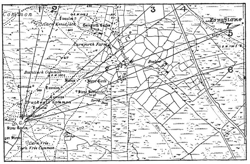
Click to enlarge
FIG. 55.—Photograph of Ordnance Map, showing sight-lines
The May-sun alignment, it may be noted, differs from that from the circle. The heights of hills when determined may give us the same solar declination; that now used gives the declination for April 28 and August 15 in our present calendar.
Regarding the alignment on Lanyon Quoit, it need only be pointed out that the Pleiades date obtained is some. 200 years after the date obtained for the analogous alignment from the circle, showing that if these two monuments—the Tregaseal circle and the Longstone—have any relationship, the removal to the high plain, now known as Woon Gumpus and Boswen Commons, was an afterthought improvement.
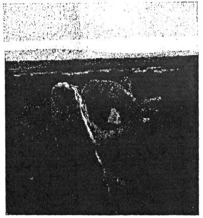
I next come to the holed stones, not only the nest of them not far from the circle, but the famous Mên-an-tol itself.
I had heard before going to Tregaseal that the four holed stones shown on the Ordnance map had been knocked down and set up again (not necessarily in their old places) two or three times. Mr. Horton Bolitho and Mr. Thomas, however, in their examination were convinced that the largest of them has never been moved. They also express the belief that the others are not more than a foot or so from their original positions, and that this change is only due to their re-erection by Mr. Cornish after they had fallen down. So far I have heard nothing of the direction of the hole in the stone which retains its original position.
Another interesting matter is that the explorers in question were able to trace an ancient stone alignment from the circle to the holed stones.
I have long held that these holed stones were arrangements for determining an alignment. The famous Odin stone at Stenness, long since disappeared,
Click to enlarge
FIG 56.—Plan of the Mên-an-tol from Lukis, showing that it was an apparatus for observing the sunrise in May and August in one direction and the sunset in February and November in the other. Sun's declination, 16° N. or S.
was, if we may trust the very definite statements made about its position, used to observe the Barnstone in one direction and the chief circle in the other.
The azimuths suggest that theodolite measures may show that the Tregaseal stones might have been used in the same way; they, the Longstone and Lanyon Quoit, are in nearly the same straight line, the alignment, holed stones to Longstone and Lanyon Quoit,
Click to enlarge
FIG. 57.—The Mên-an-tol.
Photo. by Lady Lockyer.
being N. 67° E., so that the May sunrise may have been noted in this way.
Several other monuments, e.g., Chûn Castle and Cromlech, are to be found in the immediate neighbourhood of the Tregaseal circle and the Longstone, but these will have to await further investigation as to their character and antiquity before any conclusions concerning their astronomical use can be deduced.
Not only do. we find in this neighbourhood the nest of holed stones to which I have referred, but the Mên-an-tol, the most famous of them all, in England at all events. This, then, is the place to say a few words about them. I have before stated my opinion that these stones, instead of being used as slaughter stones or posts at which to tie up the victim before sacrifice,
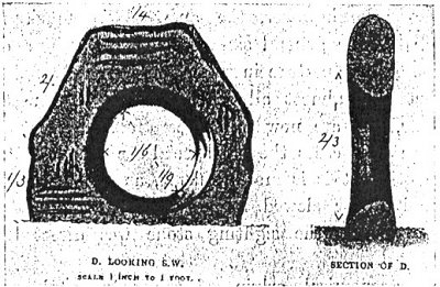
Click to enlarge
FIG. 58.—The Mên-an-tol. Front view and section, from Lukis.
or in any other similar employment, were really sighting stones to enable an alignment to be easily picked up. As such these were, of course, treated as sacred, and hence the folk-lore connected with them. This folk-lore seems to be most complete in the case of the famous stone of Odin at Stenness, so I condense Mr. Spence's account of it.
Children brought to the stone at Beltaine and Midsummer, after being carried sunwise round the holy well were passed through the hole as a protection against the powers of the evil one. Marriage ceremony consisted
of joining hands through the hole, a vow held as sacred as the legal marriage of to-day. Pains in the head cured by inserting the head in the cavity, cure of palsy in children. Children and adults travelled many miles to secure relief in this way.
At the Mên-an-tol the curative effects could only be obtained by crawling through the aperture, which is of considerable size.
As a rule, however, the aperture is much more restricted. The general size of the holed stone and the position of the aperture in it may be well gathered from the fact that almost all of them have been used for gateposts, and are now to be seen fulfilling that function. In some cases the old special use can be inferred, but in others this is more difficult, as the stones have been shifted or slewed round, or the ancient monument to which the sighting stone was directed has disappeared.
The astronomical origin of the Mên-an-tol, which obviously has never been disturbed, is quite obvious. (from Lukis) shews that it was arranged along the May year alignment, the advent of May and August, February and November being indicated by. the shadows cast by the stones through the aperture on to the opposite ones.
To the south-west the alignment for the February and November sunsets passes exactly over Chin Castle.
The "Tolmen" near Gweek, Constantine, another famous holed stone 7 feet 9 inches high and with an aperture of 17 inches, is according to a magnetic bearing I took last Easter parallel to the Mên-an-tol, and doubtless was used for the same purpose.
278:1 In Cornwall this is the name generally given to a monolith.