Sacred Texts Earth Mysteries Index Previous Next
Buy this Book at Amazon.com
Zetetic Astronomy, by 'Parallax' (pseud. Samuel Birley Rowbotham), [1881], at sacred-texts.com
THE facts and experiments already advanced render it undeniable, that the surface of all the waters of the earth is horizontal; and that, however irregular the upper outline of the land itself may be, the whole mass, land and water together, constitutes an IMMENSE NON-MOVING CIRCULAR PLANE.
If we travel by land or sea, from any part of the earth in the direction of any meridian line, and towards the northern central star called "Polaris," we come to one and the same place, a region of ice, where the star which has been our guide is directly above us, or vertical to our position. This region is really THE CENTRE OF THE EARTH; and recent observations seem to prove that it is a vast central tidal sea, nearly a thousand miles in diameter, and surrounded by a great wall or barrier of ice, eighty to a hundred miles in breadth. If from this central region we trace the outline of the lands which project or radiate from it, and the surface of which is above the water, we find that the present form of the earth or "dry land," as distinguished from the waters of the "great deep," is an
irregular mass of capes, bays, and islands, terminating in great bluffs or headlands, projecting principally towards the south, or, at least, in a direction away from the great northern centre.
If now we sail with our backs continually to this central star, "Polaris," or the centre of the earth's surface, we shall arrive at another region of ice. Upon whatever meridian we sail, keeping the northern centre behind us, we are checked in our progress by vast and lofty cliffs of ice. If we turn to the right or to the left of our meridian, these icy barriers beset us during the whole of our passage. Hence, we have found that there is a great ebbing and flowing sea at the earth's centre; with a boundary wall of ice, nearly a hundred miles in thickness, and three thousand miles in circumference; that springing or projecting from this icy wall, irregular masses of land stretch out towards the south, where a desolate waste of turbulent waters surrounds the continents, and is itself engirdled by vast belts and packs of ice, bounded by immense frozen barriers, the lateral depth and extent of which are utterly unknown.
The earth's surface is represented by the diagram, fig. 54, and a sectional view in fig. 55. N, the central open sea, I, I, the circular wall or barrier of ice, L, L, L, the masses of land tending southwards, W, W, W, the "waters of the great deep," surrounding the land, S, S, S, the southern boundary of ice, and D, D, D, the outer gloom and darkness, in which the material world is lost to human perception.
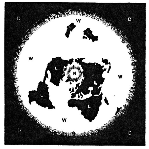
Click to enlarge
DIAGRAM OF EARTH'S SURFACE.
FIG. 54.
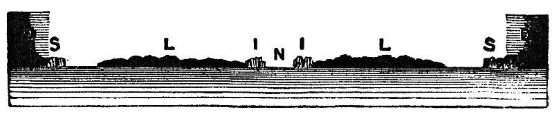
Click to enlarge
SECTIONAL VIEW OF EARTH'S SURFACE.
FIG. 55.
How far the ice extends; how it terminates; and what exists beyond it, are questions to which no present human experience can reply. All we at present know is, that snow and hail, howling winds, and indescribable storms and hurricanes prevail; and that in every direction "human ingress is barred by unsealed escarpments of perpetual ice," extending farther than eye or telescope can penetrate, and becoming lost in gloom and darkness.
The superficial extent or magnitude of the earth from the northern centre to the southern circumference, can only be stated approximately. For this purpose the following evidence will suffice. In laying the Atlantic Cable from the Great Eastern steamship, in 1866, the distance from Valencia, on the south-western coast of Ireland, to Trinity Bay in Newfoundland, was found to be 1665 miles. The. longitude of Valencia is 10° 30´ W.; and of Trinity Bay 53° 30´ W. The difference of longitude between the two places being 43°, and the whole distance round the earth being divided into 360°. Hence if 43° are found to be 1665 nautical, or 1942 statute miles, 360° will be 13,939 nautical, or 16,262 statute miles; then taking the proportion of radius to circumference, we have 2200 nautical, or 2556 statute miles as the actual distance from Valencia, in Ireland, to the polar centre of the earth's surface.
Another and a very beautiful and accurate way of ascertaining the earth's circumference is the following:--
The difference of longitude between Heart's Content Station, Newfoundland, and that at Valencia or, in other words, between the extreme points of the Atlantic) Cable--has been ascertained
by Mr. Gould, coast surveyor to the United States Government, to be 2 hours, 51 minutes, 56.5 seconds." 1
The sun passes over the earth and returns to the same point in 24 hours. If in 2 hours, 51 minutes, and 56.5 seconds, it passes from the meridian of the Valencia end of the cable to that of its termination at Heart's Content, a distance of 1942 statute miles, how far will it travel in 24 hours? On making the calculation the answer is, 16,265 statute miles. This result is only three miles greater distance than that obtained by the first process.
Again in the Boston Post, for Oct. 30th, 1856, Lieut. Maury gives the following as the correct distances, in geographical miles, across the Atlantic by the various routes (circle sailing).
|
|
Nautical |
|
Statute |
|
Philadelphia to Liverpool |
3000 |
= |
3500 |
|
New York " |
2880 |
= |
3360 |
|
Boston " |
2720 |
= |
3173 |
|
New York to Southampton |
2980 |
= |
3476 |
|
" to Glasgow |
2800 |
= |
3266 |
|
Boston to Galway |
2520 |
= |
2940 |
|
Newfoundland to Galway |
1730 |
= |
2018 |
|
Boston to Belfast |
2620 |
= |
3056 |
If we take the distance (given in the above table) between Liverpool and New York as 3360 statute miles, and calculate as in the last case, we find a nearly similar result, making allowance for the detour round the south or north of Ireland.
"The difference of time between London and New York
which the use of the electric cable makes a matter of some consequence, has latterly been ascertained afresh. It is 4 hours, 55 minutes, 18.95 seconds." 1
The results of these several methods are so nearly alike that the distance 16,262 statute miles may safely be taken as the approximate circumference of the earth at the latitude of Valencia.
If the distance from Valencia to the Cape of Good Hope, or to Cape Horn, had ever been actually measured, not calculated, the circumference of the earth at these points could, of course, be readily ascertained. We cannot admit as evidence the calculated length of a degree of latitude, because this is an amount connected with the theory of the earth's rotundity; which has been proved to be false. We must therefore take known distances between places far south of Valencia, where latitude and longitude have also been carefully observed. In the Australian Almanack for 1871, page 126 2, the distance from Auckland (New Zealand), to Sydney, is given as 1315 miles, nautical measure, which is equal to 1534 statute miles. At page 118 of the Australian Almanack for 1859, Captain Stokes, H.M.S. Acheron, communicates the latitude of Auckland as 36° 50´ 05″, S., and longitude 174° 50´ 40″, E.; latitude of Sydney, 33° 51´ 45″, S., and longitude 151° 16´ 15″, E. The difference in longitude, or time distance, is 23° 34´ 25″, calculating as in the case of Valencia to Newfoundland,
we find that as 23° 34´ 25″ represents 1534 statute miles, 360° will give 23,400 statute miles as the circumference of the earth at the latitude of Sydney, Auckland, and the Cape of Good Hope. Hence the radius or distance from the centre of the north to the above places is, in round numbers, 3720 statute miles. Calculating in the same way, we find that from Sydney to the Cape of Good Hope is fully 8600 statute miles.
The above calculations receive marked corroboration from the practical experience of mariners. The author has many times been told by captains of vessels navigating the southern region, that from Cape Town to Port Jackson in Australia, the distance is not less than 9000 miles; and from Port Jackson to Cape Horn, 9500 miles; but as many are not willing to give credit to such statements, the following quotation will be useful, and will constitute sufficient evidence of the truth of the foregoing calculations:--
"The Great Britain steamer has arrived, having made one of the best voyages homeward that has yet been effected, viz., 86 days; 72 only of which were employed in steaming; and the remaining 14 days being accounted for by detentions. She left Melbourne on January 6th, and arrived in Simon's Bay on February 10th, or 35 days. She then went round to Cape Town, whence she sailed on the 20th of February; and was afterwards detained for four days at St. Michael's and Vigo. The distance she steamed per log was 14,688 miles; which for the 72 days, gives an average of 204 miles a day." 1
If we multiply the average rate of sailing by the thirty-five days occupied in running between Melbourne and St. Simon's Bay (near Cape of Good Hope), we find that the distance is 7140 nautical miles, From Melbourne to Sydney is 6 degrees of longitude further east, or about S40 nautical miles. Hence 7140 added to 340 give 7480 nautical miles, equal to 8726 statute miles; which is 126 miles in excess of the distance given at p. 94.
The following extract furnishes additional evidence upon this important point:--
"EXTRAORDINARY VOYAGE.--Every yachtsman (says the Dublin Express), will share in the pride with which, a correspondent relates a brilliant, and, we believe, unexampled exploit which has just been performed by a small yacht of only 25 tons, which is not a stranger to the waters of Dublin Bay. The gallant little craft set out from Liverpool for the antipodes, and arrived safely in Sydney after a splendid run, performing the entire distance, 16,000 miles, in 130 days. Such an achievement affords grounds for reasonable exultation, not more as a proof of the nautical skill of our amateurs, than of their adventurous spirit, which quite casts in the shade the most daring feats of Alpine climbers." 1
A s the distance from Melbourne to Cape of Good Hope is 7140 nautical miles, as shown by the log of the Great Britain, and as the whole distance from Melbourne to Liverpool was 14,688 nautical miles, it follows that, deducting 7140 from 14,688, that the passage from the Cape of Good Hope to Liverpool was 7548 nautical miles. If we take this distance from the 16,000 miles, which the
above mentioned yacht sailed to Sydney, we have as the distance between Cape of Good Hope and Sydney, 8452 nautical, or 9860 statute miles.
In a letter from Adelaide which appeared in the Leeds Mercury for April 20th, 1867, speaking of certain commercial difficulties which had existed there, the following incidental passage occurs:--
"Just as our harvest was being concluded, the first news arrived of anticipated dearth of breadstuffs at home. The times. were so hopelessly dull, money was so scarce, and the operation of shipping wheat a distance of 14,000 miles so dangerous, that for a long time the news had no practical effect."
From England to Adelaide is here stated as 14,000 nautical, or 16,333 statute miles; and as the difference of longitude between Adelaide and Sydney is 23 degrees, equal to 1534 statute miles, we find that from England to Sydney the distance is 17,867 statute miles. Taking from this the 7548 nautical, or 8806 statute miles, we have again 9061 statute miles as the distance between the Cape of Good Hope and Sydney.
From the preceding facts it is evident that the circumference of the earth, at the distance of the Cape of Good Hope from the polar centre, is not less in round numbers than 23,400 miles. Hence the radius or distance in a direct line from the polar centre to Cape Town, to Sydney, to Auckland in New Zealand, and to all the places on the same arc, is about 3720 statute miles. And as the distance from the polar centre to Valencia in Ireland is shown to be 2556 statute miles, the direct distance from Valencia to Cape Town is 1164.
statute miles. Should it ever be shown by actual direct measurement to be more than this distance, then the distance from Cape Town to Sydney must be more than 8600 statute miles. It is a subject which must be kept open for rectification. What has already been given in the foregoing pages may be considered as the approximate minimum distances.
Having seen that the diameter of the earth's surface--taking the distance from Auckland in New Zealand, to Sydney, and thence to the Cape of Good Hope, as a datum arc--is 7440 statute miles; we may inquire how far it is from any of the above places to the great belt of ice which surrounds the southern oceans. Although large ice islands and icebergs are often met with a few degrees beyond Cape Horn, what may be called the solid immovable ramparts of ice seem to be as far south as 78 degrees. In a paper read by Mr. Locke before the Royal Dublin Society, on Friday evening, November 19th, 1860, and printed in the Journal of that Society, a map is given representing Antarctic discoveries, on which is traced a "proposed exploration route," by Captain Maury, U.S.N.; and in the third paragraph it is said: "I request attention to the diagram No. 1, representing an approximate tracing of the supposed Antarctic continent, and showing the steamer track, about twelve days from Port Philip, the chief naval station of the Austral seas, to some available landing point, bight, or ravine, under shadow of the precipitous coast." The steamer track is given on this map as a dotted line, curving eastwards from 150 degrees to 180 degrees longitude, and from Port Philip to 78 degrees
south latitude. If we take the chord of such an arc, we shall find that the direct distance from Port Philip to 78 degrees south would be about nine days' sail, or ten days from Sydney. No ordinary steamer would sail in such latitudes more than 150 statute miles a day; hence, ten times 150 would be 1500 miles; which added to the previously ascertained radius at Sydney, would make the total radius of the earth, from the northern centre to the farthest known southern circumference, to be 5224 statute miles. Thus from purely practical data, setting all theories aside, it is ascertained that the diameter of the earth, from the Ross Mountains, or from the volcanic mountains of which Mount Erebus is the chief, to the same radius distance on the opposite side of the northern centre, is more than 10,400 miles; and the circumference, 52,800 statute miles.
92:1 Liverpool Mercury, January 8th, 1867.
93:1 Liverpool Mercury, June 3rd, 1867.
93:2 Published by Gordon and Gotch, 121, Holborn Hill, London; and 281, George Street, Sydney, and 85, Collins Street West, Melbourne, New South Wales.
94:1 Australian and New Zealand Gazette, for April 9th, 1853. Published by A. E. Murray, Green Arbour Court, Old Bailey, London. A copy may be seen in the Liverpool Free Library, in "No. 10 Section."
95:1 Cheltenham Examiner (Supplement), for November 29th, 1865.