
Pale Ink, by Henriette Mertz, [1953], at sacred-texts.com
CHAPTER XIII
Across the Sea
The Fourth Book of the Classic of Mountains and Seas, entitled "The Classic of the Eastern Mountains," is divided into four sections—other than that each pertains to the "Eastern Mountains" no one of the four sections is related to any one of the others.
The first section of the Fourth Book, identified a range of mountains approximately 1200 miles in extent, running due north and south. Twelve peaks have been named, each having a river flowing in an easterly direction—northeast, east or southeast. The second section climbed over mountainous territory for 2200 miles, also due north and south. The third section took a water course, due north and south for approximately 2000 miles. The fourth section was short, starting at the "North Sea" and travelling south and east.
There may be some indication in the untranslated portions that I do not have, that told how the Chinese got across the Eastern Sea to the Eastern Mountains. Since it is not available, to decide independently how they got there, would only be pulling a conclusion out of thin air. Therefore, with no apology, we shall jump across and only try to solve the geographical problems that we actually have.
The first identification of a mountain range that was described in the Classics, Book Four, Section 1, appeared that it might be the Cascades or Sierras, since they were coastal and fulfilled the requirement in that they ran north and south for more than 1200 miles. All rivers on the coastal range, however, emptied into the Pacific—to the west. The Cascades and Sierras, therefore, had to be eliminated—the rivers ran in the wrong direction. The Andes were then considered as a possibility, as that great range, extending north and south, had all major rivers flowing easterly to the Atlantic. The eastern slope of the Andes is one tremendous rain-forest. One of the items in the Classics stated that the recorder travelled for a time over shifting sand—there was no shifting sand on the eastern slope of the Andean
range; that range was then eliminated. The only remaining range of great extent would be the Rockies. There, rivers did flow in an easterly direction—into the Mississippi basin.
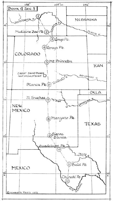
The opening sentence of the section started out by saying that "Suh-Chu Mountain" on its northern side adjoined the "Sunless Mountain" and that drinkable water was found in a river flowing northeasterly. I chased up and down a dozen or more times on my map, from Canada to Mexico, and each time examined every peak without even a flicker of a clue. Being unable to locate "Suh-Chu Mountain" or the good drinking water, I finally passed it over. The second peak had to be passed over for the same reason. The third one "rang a bell." The Chinese had named it "Aspen Mountain." "Aspen," to me, meant only one thing—Estes Park, Colorado. Taking a chance that the third peak was somewhere in Colorado, I pinpointed it there. From that point, I worked both forward and backward. Going backward to peak number one, "Suh-Chu Mountain," I found myself looking at Sweetwater River, in Wyoming, flowing northeast—good drinking water. Working my way down the map, the shifting sand, the sand that had eliminated the Andean range, was found precisely on the spot where the Chinese had placed it—and today, we have commemorated that spot, unknowingly insofar as the Chinese were concerned, with our Great Sand Dunes National Monument. From then on, peak after peak tallied. It seemed unbelievable at first—but it worked. If the first one worked, the others would have to do so.
In a few spots, winding through Tennessee Pass, Berthoud Pass, Rabbit's Ear Pass or Fall River Pass, mileage is about twenty miles short. But, in 1200 miles, a few minor errors of 4000 years ago can be forgiven, particularly if one knows that frightfully rugged terrain.
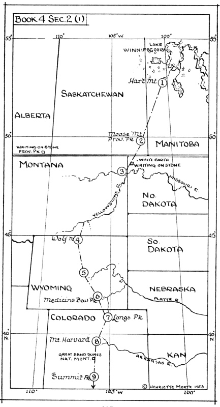
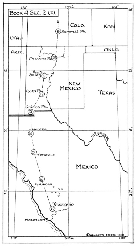
When one considers the difficulties and dangers of conquering one mountain peak and then can form a mental picture of himself trekking down 2200 miles over 17 peaks, on the very crest of the Continental Divide, from Manitoba to Mazatlan, some small appreciation of the seemingly insurmountable task will be understood. We can do no more than to stand with
bowed heads before the intrepid Chinese who mapped those jagged snow-capped peaks over 4000 years ago.
That their record has survived until today is, likewise, one of those peculiar turns of fate that make the reality of it stranger than fiction.
THE CLASSIC OF MOUNTAINS AND SEAS 1
Fourth Book
THE CLASSIC OF THE EASTERN MOUNTAINS
1. The beginning of the "Classic of the Eastern Mountains" says that SUH-CHU Mountain on its northern side adjoins KAN-MEI Mountain (or Sunless Mountain). SHIH River (or "drinkable water") is found here, a stream that flows northeasterly into the sea. In it there are many water animals called YUNG-YUNG. These look like brindled cattle [i.e., they resemble cattle that are striped like tigers.] . Their voices sound like the grunting of swine.
2. And it says that, three hundred LI to the south, LEI Mountain (or the Mountain of Creeping Plants) is to be found. Upon this there are gems and below it there is gold. Hu River is found here, stream that flows easterly into SHIN River. In this there are many HWOH-SHI. [These are tadpoles; the book entitled the RH’-YA calls them HWOH-TUNG.]
Click to enlarge
Book 4 Sec. 1
3. And it says that, three hundred LI to the south, KEU-CHWANG Mountain (or Aspen Mountain) is to be found. Upon this there are many gems and much gold, and below it many green jade stones. Wild animals are found there which look like dogs with six legs. These are called TS’UNG-TS’UNG, the name being given them in imitation of their cry. Birds are also found there which look like domestic fowls, but which have hair like a rat. These are called TSZ’ rats. When they are seen, the country is subject to great draught. The CHI River is found here, a stream flowing northerly into Hu River. In this there are many lancet-fish. These are of a dark color, spotted (or striped) with blue, and have a bill like a lancet. [These were originally found in the Eastern Sea, and they are now found in the KIANG-TUNG River also.] Those who eat them are not subject to epidemic diseases.
4. And it says that, three hundred LI to the south, PUH-T’SAN Mountain is found. It has no grass or trees, and no water.
Note: Of four or five major peaks approximately 100 miles
south, Gray's Peak appears to be the one noted by the Chinese.
5. And it says that, three hundred LI to the south, FAN-T’IAO Mountain (or the Foreign Range) is to be found. It
has no grass or trees, but has much sand. The KIEN River (Diminishing River) is found here, a stream flowing northerly into the sea. In this there are many KAN fish. (The KAN fish is described as a fish three feet long, that is found in the YANG-TSZ’ River, having a large mouth and yellowish gills, and a greenish back.) [One authority names these "the yellow-jawed fish."]
6. And it says that four hundred LI to the south, KU-MAO Mountain (or the Mountain of the Maiden) is found. Upon this there are many lacquer-trees, and below it many mulberry trees, and silk-worm oaks. KU-MAO River is found here, a stream flowing northerly into the sea, in which there are many KAN fish.
7. And it says that, four hundred LI to the south, KAO-SHI Mountain is to be found. Upon this there are many gems and below it many sharp stones. [From these they are able to make smooth lancets to cure boils and swellings.] CHU-SHING River is found here, a stream flowing easterly into a marsh, and in it there are many gems and much gold.
8. And it says that, three hundred LI to the south, YOH (Lofty) Mountain is found. Upon this there are many mulberry-trees, and below it many ailanthus-trees. LOH River is
found here, a stream flowing easterly into a marsh, and in it there are many gems and much gold.
9. And it says that three hundred LI to the south, Wolf Mountain is to be found. Upon this there is no grass and there are no trees, and below it there is much water (or there are many streams), in which there are many KAN-TSZ’ fish. [These are not fully described.] They have wild animals, which look like the (quadrumana, called) KW’A-FU, but they have hair like that of swine, and their voice is like an expiration of the breath.
When these are seen, then heaven sends down great rains.
10. And it says that, three hundred LI to the south, Lone Mountain is found. Upon this there are many gems and much gold, and below it many beautiful stones. MOH-T’U (Muddy) River is found here, a stream flowing southeasterly into a mighty flood, in which there are many T’IAO-YUNG. These look like yellow serpents with fishes fins. They go out and in. They are bright (or smooth). When these are seen, then the region is subject to great draught.
11. And it says that, three hundred LI to the south, T’AI (Bald) Mountain is found. [Then the mountain was called the Eastern YOH or T’AI-TSUNG, which is now called T’AI Mountain. It is in the northwestern part of FUNG-KAO District, and the distance from the foot of the mountain to its summit is forty-eight LI and three hundred paces.] Upon this there are many gems, and below it there is much gold. Wild animals are found here which look like sucking pigs, but they have pearls. They are called TUNG-TUNG, their name being given in imitation of their cry. The HWAN River is found here, a stream flowing easterly into a river (or into the river. i.e. The YANG-TSZ’ River). [One authority says that it flows into the sea.] In this there are many water-gems (quartz crystals).
12. And it says that, three hundred LI to the south, Bamboo Mountain is found, bordering on a river (or the river). [One authority says that it is on the shore—or that it is at the boundary line.] There is no grass or trees, but there are many green-jasper and green-jade stones. The Km River (or water impeded in its course by rocks) is found here, a stream flowing southeasterly into TS’U-TAN River (or a body of water). In this (country) there is a great abundance of dye-plants!
13. The first section of the "Classic of the Eastern Mountains" thus gives the entire distance along the twelve mountains, from SUH-CHU Mountain to Bamboo Mountain, as three thousand six hundred LI. Their gods all have human bodies and dragon's heads. When they are offered a sacrifice of animals having hair, a dog is used. In other sacrifices the blood of a fish is used to besmear the things offered. [To use blood in besmearing the things offered in sacrifice is called "NI." KUNG-YANG'S "Chronicles" say that in offering sacrifices of creatures having flesh and blood, to the god of the land, and of grain, they besmear with blood the being that is sacrificed. The name of this species of sacrifice is pronounced "NI."]
Second Section
1. The beginning of the second section of the "Eastern Classic" says that K’UNG-SANG Mountain (or the Mountain of the Empty Mulberry-Trees) on the northern side adjoins the SHIN River. [This mountain rises from the KIN-SEH Forest—see the book called "CHEU-LI."] On the eastern side (it adjoins the states of) Tsu and Wu; on the southern side a number of sandy mounds, and on the western side the MIN (or Muddy) Marsh. Here there are wild animals which look
Click to enlarge
Book 4 Sec. 2 (1)
Click to enlarge
Book 4 Sec. 2 (2)
like cattle, but which are striped like tigers. Their voices resemble the sound of a person stretching and yawning. [Perhaps rather the sound of one moaning.] These are named LING-LING, and this name is an imitation of their cry. When these are seen, then heaven sends down great rains.
2. And it says that, six hundred LI to the south, TS’AO-CHI Mountain is found. Below this there are many paper-mulberry trees, but there is no water (or river). There are many birds and wild animals.
3. And it says that, four hundred LI to the southwest, YIH-KAO Mountain is found. Upon this there are many gems and much gold, and below it there is much white plaster-rock. The YIH-KAO River is found here, a stream flowing easterly to the KIH-NU River. In this there are many clams with pearly shells. [These are clams or mussels with pearly shells, as beautiful as gems, these pearly shells belonging to a species of mussel called SHAN-PAN.]
It may well be that the most incredible coincidence of all will be found to be located right here. In this precise area, due north of Grenora, in the northwest corner of North Dakota, stands a large boulder on which is inscribed undecipherable carvings said to predate the earliest known tribesmen. This boulder falls within the immediate path of one travelling from Moose Mountain Provincial Park to the confluence of the Yellowstone with the Missouri. The probability seems undeniably strong that this marker was carved and left there by those first world map-makers sent out by Yu.
A second series of inscribed rocks of the same nature, is located in the southeast corner of Alberta, Canada, ten miles over the border. The Canadian Government has created Writing-on-Stone Provincial Park around the area. These obelisks are also covered with undecipherable hieroglyphics. It is my belief that if study were made of both stone carvings, that in Alberta and that in North Dakota, it might be found to be that the hieroglyphics were an archaic form of Chinese—such, for example, as were found inscribed on the bones dug up in China, described earlier. The stone in Alberta would lie in a probably path of those coming south, preceding Section One, where our first identification started at the Sweetwater River—the beginning of the section being lost.
The carvings are undecipherable—they are known to be ancient. They lie in what I believe to be the path of the early Chinese, as indicated on the second map. If the inscriptions, after study, are found to be archaic Chinese, we will then have the necessary "bones," located on the spot, which archeologists must have, as well as the documentary proof.
They spoke also of gold and gems. Unusually fine agate is found in the area and gold in quantity, as is well known.
4. And thence going to the south, five hundred LI by water, and three hundred LI over shifting sands, one end of the KOH (or Bean) Mountain is reached. There is no grass and there are no trees here, but there are many smooth whetstones.
5. And it says that, three hundred and eighty LI to the south, the other end of Bean Mountain is found. There is no grass and there are no trees here. The LI River is found here, a stream flowing easterly into the Yu Marsh. In it there are many CHU-P’IEH fish (or water animals). These look like lungs, but have eyes and six feet, and they have pearls. They taste sour, but pleasant, and are eaten without producing sickness. [They do not cause diseases at any time. LU-SHI'S edition of the book of Confucius, called "Spring and Autumn," says that the LI River contains fish called CHU-PIEH, which have six feet, and which are beautiful as the "vermilion" fish.]
6. And it says that, three hundred and eighty LI to the south, YU-NGO Mountain (or an excessively high peak) is found. Upon this there are many japonica-trees and JAN-trees, and below it there is much prickly succory. The TSAH-YU River is found here, a stream flowing easterly into the Yellow River. Here there are wild beasts which look like rabbits, but which
have a crow's bill, an owl's eyes, and a serpent's tail. When they see a man, they pretend to sleep. They are called CHIU-YU, this sound being an imitation of their cry. When these are seen, grasshoppers or locusts cause great destruction. [Grasshoppers are a species of locusts. It says that they ruin the herbage. Their name is pronounced CHUNG.]
7. And it says that, three hundred LI to the south, TU-FU Mountain is found. There is no grass and there are no trees here, but there is much water (or there are many streams).
8. And it says that, three hundred LI to the south, KANG Mountain is found. There is no grass and there are no trees here, but there is much water, and there are many green-jade stones (or there are many water-jade stones). [These are a species of water-gems—i.e., rock crystals.] There are many great serpents, and there are also wild beasts which look like foxes, but which have fish's fins. These are named CHU-JU, and derive their name from their cry. When these are seen, the country has reason to fear disasters.
9. And it says that, three hundred LI to the south, LU-K’I Mountain is found. There is no vegetation, and there are no trees, but there are many stones and much sand. The Sand River is found here, a stream flowing southerly into the CH’AN River (or into a limpid river). In this there are many LI pelicans; these look like ducks, but have men's legs. They derive their name from their cry. When these are seen, then the country will see great literary achievements. [These pelicans have long legs, which somewhat resemble human shanks.]
10. And it says that, three hundred and eighty LI to the south, KU-SHE Mountain is found. There is no grass and there are no trees there, but there is much water (or there are many streams).
11. And it says that, going to the south, three hundred LI by water, and one hundred LI over shifting sand, the northern KU-SHE Mountain is found. There is no grass and there are no trees there, but there are many stones.
12. And it says that, three hundred LI to the south, Southern KU-SHE Mountain is found. There is no grass and there are no trees there, but there is much water (or there are many streams there).
13. And it says that, three hundred LI to the south, Green-jade-stone Mountain is found. There is no grass here but there are many trees. Many great serpents are found here, and there are also many green-jade stones and quartz crystals.
14. And it says that, five hundred LI to the south, W’EI-SHI Mountain is found. There is no grass and there are no trees here, but there are many gems and much gold. YUEN River is found here, a stream flowing easterly into a sand marsh (or into a sandy marsh). [One authority states that the name of the mountain is pronounced KIAH-SHI instead of W’EI-SHI.]
15. And it says that, three hundred LI to the south, KU-FUNG Mountain is found. There is no grass, and there are no trees here, but there are many gems and much gold. Wild beasts are found here which look like foxes, but which have wings (or
fins). Their voice sounds like that of a wild goose, and they are called PI-PI. When these are seen, then heaven sends down great draught.
16. And it says that, five hundred LI to the south, FU-LI Mountain is found. Upon this there are many gems and much gold, and, below it, many lancet-stones. They have wild beasts which look like foxes, but which have nine tails and nine heads, and tiger's claws. They are called LUNG-CHIH. Their voice is like that of an infant child, and they eat men.
17. And it says that, five hundred LI to the south, YIN Mountain is found. To the south, the YIN River is to be seen, and to the north the Hu Marsh (or lakes and marshes). Here they have wild beasts which look like horses, but they have sheep's eyes, four horns and cattle tails. Their voice is like the howl of a dog, and they are called YIU-YIU. When these are seen, the country will be visited by many crafty foreigners. They have birds which look like ducks, but they have rat's tails, and can climb trees. They are called CHIE-KEU. When these are seen, the country will have much sickness.
18. The second section of the "Classic of the Eastern Mountains" thus gives the entire distance along the seventeen mountains, from KUNG-SANG Mountain to YIN Mountain, as six
thousand six hundred and forty LI. Their gods all have wild beast's bodies, but human faces. They bear the KOH fish. [With a species of stag's or deer's horns they catch the KOH fishes.] When they are offered a sacrifice of living beings having hair or feathers, a fowl is used. When the people pray to them for offspring, they retire to a screened place.
Third Section
1. The beginning of the third section of the "Eastern Classic" says that, SHI-HU Mountain on the north adjoins SIANG Mountain. Upon it there are many gems and much gold, and below it there are many thorny plants. Here there are wild beasts which look like elks, but which have fish eyes, and they are called WAN-HU (or YUEN-HU), deriving their name from their cry.
Click to enlarge
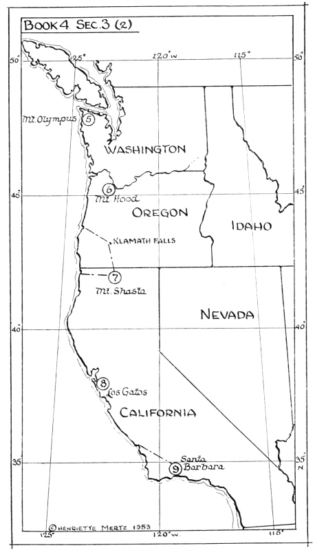
Book 4 Sec. 3 (1)
Click to enlarge
Book 4 Sec. 3 (2)
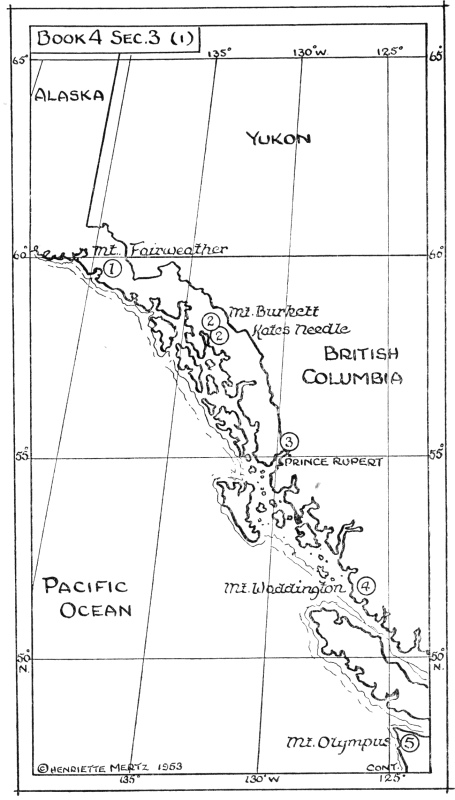
2. And it says that going to the south by water for eight hundred LI, K’I Mountain is found (or a mountain with two peaks). Upon this there are many peach-trees and plum-trees. There are also many wild beasts and many tigers.
Travelling from Mt. Fairweather, eight hundred LI, or roughly 266 miles, south, the twin peaks of Mt. Burkett and Kates Needle stand, separated by a glacier, immediately north of Wrangell. This portion of the Alaskan coast is warmed by the waters of the Kamchatka Current so that in spite of its northern latitude, fruit trees grow there in a tempered climate, today. Scientists believe that in the early periods of the Christian era, or before 900 A.D., climatic conditions in the polar regions were far different from what they are now. They were temperate, or even warm. We know that to be true of the north Atlantic at the time of the crossing of the Norsemen. As glaciers recede in Greenland, villages are being uncovered. Rachel Carson speaks of it in her magnificent book "The Sea Around Us."
3. And it says that, going to the south by water for five hundred LI, CHU-KEU Mountain is found. There are no trees or grass here, but there are many stones, and much sand. The distance around the mountain is one hundred LI. There are many MEI (or sleeping fish) here. [These MEI fish are of excellent flavor.]
4. And it says that, going south by water for seven hundred LI, Middle FU Mountain is found. Here there are no trees or grass, but there is much sand.
5. And it says that, going to the east by water for one thousand LI, HU-SHE Mountain is found. Here there are no trees or grass, but there are many stones and much sand.
6. And it says that, going to the south by water for seven hundred LI, MANG-TSZ’ (the Eldest Child) Mountain is found. Here there are many trees; japonicas and T’ONG trees, and also many peach-trees and plum-trees. In the grass there are many mushroom-rushes (or mushrooms and rushes, or KIUN rushes). [These are not fully described. They are called KW’UN.] They have wild beasts, and many elks and deers. The distance around the mountain is one hundred LI. Upon it there is a flowing stream called PIH-YANG (or the river of Clear Jade-stone). In this there are many sturgeons and mud-sturgeons. [These mud-sturgeons are a species of eel. They resemble sturgeons, but have a long body like an eel. One authority says that they are a species of herring.]
7. And going south by water for five hundred LI, and over shifting sand for five hundred LI, a mountain is reached which
is called K’I-CHUNG Mountain, the distance around which is two hundred LI. There is no grass and there are no trees here, but there are great serpents, and upon the mountain there are many precious stones. It has a body of water, the distance around which is forty LI, all bubbling up and running off. [Now, to the east of the Yellow River is the FAN River, and in the YIN (Dark) District it has the FUN River's Spring (or source). In this place the water rushes out, overflowing, bubbling up, and running rapidly. It is deep and can not be restrained. This is of the same class as the water above referred to.] This is called SHAN-TSEH (or the Deep Marsh). In it there are great tortoises. [They have beaks like the common tortoise, the tortoise being a great turtle; the shell has variegated marks, like those of the precious tortoise-shell, but it is thinner.] Here there are fish (or water animals) which look like carp, which have six feet and a bird's tail. These are called KOH-KOH fish, deriving this name from an imitation of their cry.
8. And it says that, going to the south by water for eight hundred LI, MEI-YU Mountain [or MIN-TSZ’] Mountain is reached. Upon this there are many trees and much grass, and
an abundance of gold and gems, and also much ocher. Here there are wild beasts which look like little cattle, but which have horse's tails, and which are called TSING-TSING, deriving their name from an imitation of their cry.
9. And going to the south by water for five hundred LI, and over shifting sand for three hundred LI, WU-KAO (or Not Lofty) Mountain is reached. Here the YIU (Young) Sea may be seen. [This is now called the "Little Sea."] To the east the FU-tree may be seen [or FU-SANG] . There is no grass and there are no trees here, and much wind is found upon the mountain. The distance around it is a hundred LI.
10. The third section of the "Eastern Classic" thus gives the entire distance along the nine mountains, from SHI-HU Mountain to WU-KAO Mountain, as six thousand eight hundred LI. Their gods all have human bodies and sheep's horns. When a sacrifice is offered to them, a ram is used. They use millet for food. When these gods are seen, then wind, rain, and floods cause ruin.
Again, there is a description of the Katchina—human bodies and sheep's horns—and that in 2250 B.C., identified with the prayer for rain.
Fourth Section
1. The beginning of the fourth section of the "Eastern Classic" says that the Northern HAO Mountain slopes down to the North Sea. It has trees which look like Aspens, but which have red flowers. The fruit is like the jujube, but it has no pit. It tastes sour, but delicious. It is eaten without causing any ill results. The Stull River (or drinkable water) is found here, a
stream that flows northeasterly into the sea. Here there are wild animals which look like wolves, but which have red heads and rat's eyes. Their voices sound like those of sucking pigs, and they are called HIEH-TSU. They eat men. There are birds here which look like domestic fowls, but have white heads, rat's legs, and tiger's claws. They are called KWEI [or K’I] birds, and they eat men.
2. And it says that, three hundred LI to the south, MAO Mountain is found. Here there are no trees and no grass. The TS’ANG-T’I River is found here, a stream flowing westerly into the CHEN River (or a large body of water). In this there are many SIU fish. [These are shrimps, or the eels indicated by the character TS’IU, and possibly the character SIU was then pronounced the same as TS’IU.] These look like the carp, but have a larger head. Those who eat them have no swellings.
3. And it says that, three hundred and twenty LI to the south, the Eastern SHI Mountain is found. Upon this there are many green gems. Here there are trees which look like aspens, but which have red veins. Their sap is like blood, and they have no
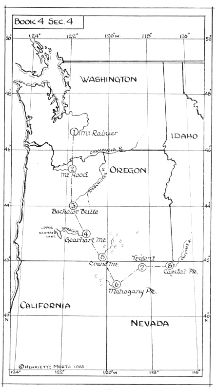
Click to enlarge
Book 4 Sec. 4
fruit. These are called K’I. They can break horses by its use [i.e., by rubbing them with this sap, horses become tame and gentle.] Clear River is found here, a stream flowing northeasterly into the sea. In this there are many delicious cowries and many cuttle-fish. These look like a goby, and have only one head with ten bodies. They smell like sedge-grass or a jungle. Those who eat them have no asthma. [It says that they cure the disease which consists of a difficulty in breathing.]
4. And it says that, three hundred LI to the southeast, NU-CHING Mountain is found. Upon this there are no trees, grass, or stones. KAO (Rich, Fertilizing) River is found here, a stream flowing westerly into LIH (Cauldron) River. In this there are many thin fish which look like herring, but have only one eye. Their voice sounds like vomiting [i.e., like the sound of a man retching and vomiting]. When these are seen, then heaven sends down a great draught.
5. And it says that, two hundred LI to the southeast, the KIN (Imperial or Majestic) Mountain is found. Here there are many gems and much gold, but no stones. The SHI River is found there, a stream flowing northerly into KAO Marsh. In this there are many eels and cowrie-shells. Here there are wild animals which look like sucking pigs, but which have tusks. These are called TANG-K’ANG, deriving their name from their cry. When these are seen, then heaven causes the earth to produce much grain.
6. And it says that, two hundred LI to the southeast, TSZ’-T’UNG Mountain is found. TSZ’-T’UNG River is found here, a stream flowing westerly into YU-JU Marsh. In this there are many HWAH fish. These look like fish, but have bird's wings. They go out and in. They are bright. Their voices sound like those of the YUEN-YANG. When these are seen, then heaven sends down a great drought.
7. And it, says that, two hundred LI to the northeast, YEN (Sharp-pointed) Mountain is found. Here there are many precious stones and much gold. There are also wild beasts which look like swine, but which have men's faces and yellow bodies, but red tails. These are called HOH-YU. Their voices sound like that of an infant child. These wild animals eat men, and eat vermin and serpents. When these are seen, then heaven sends down great rains.
8. And it says that, two hundred LI to the east, T’AI (Immense) Mountain is found. Upon it there are many precious stones and much gold, and there are also many wax-trees. [These wax-trees do not shed their leaves in winter.] Here there are many wild animals which look like cattle, but which have a white head, one eye, and a serpent's tail. They are called FEI. When they go upon the water, they dry it up, and when they go upon the grass, they kill it. When these are seen, then heaven sends down a great pestilence. [It says that its body is full of a poisonous principle. The book called "K’I-KIN" says that it is a locust or cricket called K’IUNG. Its body looks harmless, but it causes the veins to wither and dry up, being more poisonous than the CHAN. All creatures fear it, and wish to keep at a great distance from it.] The KEU River is found here, a stream flowing northerly into LAO River. In this are many fish.
9. The fourth section of the "Eastern Classic" thus gives the entire distance along the eight mountains, from HAO Mountain to TAI Mountain, as one thousand seven hundred and twenty LI.
10. The above record of the "Classic of the Eastern Mountains" thus gives the distance along these forty-six mountains as eighteen thousand eight hundred and sixty LI.
In this Fourth Book of the Classic of the Eastern Mountains, compiled, according to the Chinese in 2250 B.C., we have set forth the translation as it was found. We faithfully followed directions, as promised at the start, and in every instance, where we were told to go south 100 miles, we went south 100 miles—where we were directed to go by water, even in the interior, we went by water. Every mountain was found where the Chinese said it would be found—all rivers with the exception of two in the desert area, were found and found to flow in the proper direction. In two sections, I got lost in the tortuous mountain passes and came out short on mileage. I do not overlook the fact that errors are bound to be present—they are inescapable.
On this Chinese "Cook's Tour," we thrilled with them at the sight of the golden aspen trees in Colorado; trekked across the Great Sand Dunes National Monument; saw the wild life in Canada and the pearly mussels in the Musselshell River; picked up black opals and a few nuggets in northern Nevada and turquoise in New Mexico; took a side excursion to see Klamath Falls and Mt. Shasta; watched the seals sporting on the rocks in San Francisco Bay; enjoyed eating the Columbia River salmon; were amused by the ’possum pretending to sleep; and finally came to the place where the FU-tree grew—just where Hwui Shan had said it did—2700 years later.
On each one of these four journeys, the most outstanding characteristic of the region, as we know it, was the thing noted by the Chinese—and many of them we have set aside as National Parks.
This is the mile by mile record that the ancient Chinese kept in their bamboo note-books.
Footnotes
110:1 The information contained within the square brackets is a part of the Chinese text as it appears in the Classics. The notes were put there by a scholar at an early date who no doubt was trying to locate the mountains and rivers in China. Information within the parenthesis is a contribution of the translator from Chinese to English.