
Sacred Texts Legendary Creatures Index Previous Next
Buy this Book at Amazon.com
Buy this Book on Kindle
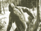
Abominable Snowmen, by Ivan T. Sanderson, [1961], at sacred-texts.com
18. Some Basic Facts
Having now met the ABSMs, you may well be a bit bewildered, and the over-all impression you have gained of them will still be that they are a pretty polyglot lot. Likenesses between two or more there can be but, on the whole, there does not appear to be any one feature common to all. This, however, is a gross misconception. As with so many things in life, the whole question has been presented popularly on completely false premises, or has, at least, been given a wrong twist, which is not only most misleading, but initially set us all off on the wrong trail. The causes of this are singular, and psychologically, very potent. They are basically, the name, "abominable snow-man," that has become attached to it. This is the one single, outstanding fact that has become attached to all ABSMs. Yet, none of them live in snow, or in any place that is either perpetually, or even for any substantial part of the year covered by snow. This, indeed, is a negative fact but it is of very great import because it has led to the misdirection of almost all our serious attempts to solve the problem.
There is much misinterpretation of all the evidence—notably in the department of footprints and tracks, which have always, as a result, been immediately assumed to have been made in snow. [Tracks and imprints made in snow can be most misleading in a number of ways and are open to all manner of interpretations. See Appendix B.] Those left in
mud have altogether other significance. The best and sometimes the only evidence we have of the existence of many creatures is nonetheless most frequently seen on snow surfaces and, since snow does fall upon and lie on the ground in many areas where ABSMs are reported, or near to those places, it is in a way natural that the two should have become associated. However, the search would never have followed the course that it has, and it might well by now be over, had it not been for the coining of the delightful but nonetheless nonsensical term "snowman." *
There is, however, another feature that all ABSMs have in common. This has remained just as obscure as the snow bit has been prominent. It is that all of them are forest dwellers and, it seems, basically inhabitants of mountain forests. Even the Malay Peninsula types, the Sumatran Sedapas, the little African Agogwes, and the Central American Dwendis, though sometimes reported from sea level or even from coastal beaches, are invariably hard by large mountain blocks or substantial uplands that are not inhabited by humans and which are mostly unmapped and unexplored. The only terrain where as yet unidentified creatures of larger sizes can exist today is that which is forested, be it equatorial rainforest [i.e. jungle to most people], taiga or spruce forest, or even the endless mulga of Australia. Among forests, moreover, the two most likely types to be inhabited by such creatures are swamps and mountains. Almost all of the "new" animals that have come to light in this century have been found in one or other of these sorts of forest; and with a considerable emphasis on the mountainous.
Given the misleading tag of "snowman," our whole search has been further diverted by a really extraordinary sort of mass blindness that must be basically psychological. While tracks have on many occasions been found in snow and at high altitude—there not otherwise being snow at the latitudes
Click to enlarge
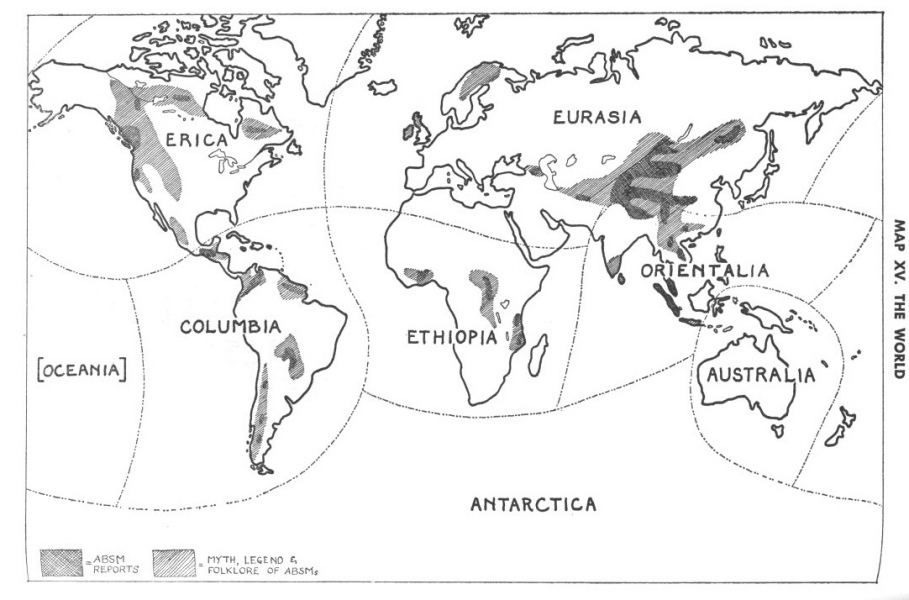
MAP XV. THE WORLD
MAP XV. THE WORLD
concerned—and while some of these tracks have been followed for some distances, and continued in snow, an end has never yet been found to any one of them that do not either come from or return to forests. Nobody seems ever to have considered the fact that our own human tracks in snow, especially crossing high passes in such places as the Himalayas, in no way indicate that we live in places of perpetual snow. Quite apart from this, it would seem obvious that no creature, even of our size, could find enough food in any such place to reside there perpetually. Mountain snowfields in the tropics, sub-tropics, temperate, and sub-arctic belts are perpetual and, unlike the Arctic lowlands where the snow vanishes for some months each year, are not underlain by a mat of rich vegetation which may be dug or scratched for in winter. A limited number of larger animals, like the Muskox and Reindeer, can gain a living on the Arctic lowlands but none live on or can survive on ice, on snowfields, or on icecaps such as those of Greenland and the Antarctic; and none can live on the perpetual montane snowfields of other areas. ABSMs may, and often do, it seems, live right up near the tree-line [mostly because that is their last retreat] and they naturally and customarily cross over the upper snowfields to
get from one valley forest to another and particularly when disturbed by loathsome mountaineers! Gerald Russell's observations on this are most pertinent.
Even the Russians were initially misled into sending all of their scientifically mounted expeditions up into the worlds of perpetual snow and bare rocks—in the Caucasus, in the Pamirs, on the Tibetan side of the Everest Block, and in the Sayans. Some of their first reports in 1958 displayed distinct surprise at their failure to locate any evidence of the creatures in these places while the map they issued showed their belief that ABSMs not only lived in, but had their only remaining breeding ground in such an area in the Pamirs. The truth of the matter is they, like everybody else, were more or less hypnotized by the silly expression "snowman." At the same time, neither they nor anybody else seems ever to have mapped the world distribution of reports of ABSMs, plus the MLF of ABSMs—though the Russians did attempt this for Eurasia. But, of much greater significance, is the fact that not even they correlated that map with the one factor that is of paramount importance in elucidating the distribution of any and all living things—as well as a host of other matters such as disease, civilization, industry, and so forth. This is the distribution of vegetational types.
The study of vegetation, though a department of botany, has very little to do with the details of that subject; more especially when it is the geographical aspects of it that we are investigating. Plant geography, or phytogeography as it is called, concerns the geographical distribution of species, genera, families, and/or larger groups of plants; the study of vegetation is concerned with the distribution of the various types and forms of growth of plant-associations. In the latter, the actual species, genera, families, or bigger groups of plants themselves really do not matter at all; it is the manner in which they grow—namely, to what height, how close together, in what form (as trees, shrubs, or herbs), and so forth. Thus, any one patch of vegetation in one area may have as its dominant tree a palm, but in another a broad-leafed, hardwood, deciduous tree, and in still another a pine, yet all three "forests"—if they be such-
may be of the same vegetational type. Further, an area of, let us say, orchard-bush, in one place may consist of one kind of stunted acacia tree, standing widely apart with, under and between these trees, tall grasses of two species; but, suddenly, in an adjacent area, the whole scene may change—often along a very precise line—to tall trees of the same species, but standing much closer together and having only short grass below; and this grass may be of a new species or one of the first two or both. In other words, the appearance of the vegetation has changed but the plant species have not. This is called a change of facies, a term borrowed from the geologists, who first coined it to define the appearance of strata of rocks in various places, which may be totally unlike: thus, in one place a shale, in another a sandstone, in a third a limestone may be found, and yet all still be of the same age and laid down, or deposited, under the same shallow sea.
The study of vegetation is a grossly neglected science and, although it has played a very lively part in geography, and especially in animal and plant geography, since long before mere plant distribution studies were initiated, it has never been given the place it warrants. In fact, there is not yet even a single textbook devoted to it, as opposed to general phytogeography. And yet, the whole of plant, and animal, distribution is wholly dependent upon it; while, all the most important aspects of human life such as agriculture, much of industry, and even nationality, race, and all the larger characteristics and characters of human beings are wholly subservient to it. It is amazing that the last thing to be mapped in any country has been and still is its vegetational forms. Only one state in this Union has done this—California—while there are states, like Texas, that have vast afforestation, soil bank, and other programs which are entirely dependent upon detailed knowledge of the distribution of vegetational types and facies, but that do not yet have a single map of any such.
Actually, the most important map of any piece of land is a vegetation map. Even topography [showing altitude] is really of minor importance. To zoology, and such matters as stock raising, it is not only just essential, but so vital that it really
amounts to the only feature of the land concerned that is needed. As a very broad example, it may be noted that nearly all our cattle are of the wrong breeds for the vegetational belts and zones in which we now keep them and try to raise them. Take the Hereford breed of cattle, for instance. These were developed in Herefordshire in England in the middle of the southern North Temperate Deciduous Forest Belt, yet we try to raise them on prairies, scrub belts, and near deserts and then we wonder why this stock deteriorates and needs constant infusion of new blood from the old (original) country. The cattle that should roam our Western ranges, and by the millions, are either Masai or Ankole bighorns from Africa, or Sindi Humped Cattle from Pakistan. And so it goes with almost every animal and plant that man tries to rear; as well as to man himself. Hollanders from the coastal marshes of Europe are never going to thrive in upland Colorado; Spaniards from the windy desiertos of upland Spain are not even going to survive in the Canadian boreal pine forests or in the Florida everglades. They either die out, or move out.
The mapping of vegetation is thus the sole most important task for the terrestrial geographer. Details of rainfall, topography, soils, and all the rest are purely secondary and can come later. And colonizers, agriculturists, stock raisers, and others would be well advised to drop all other studies until that has been accomplished.
If, therefore, we want to attempt any sort of interpretation of the distribution of any living thing, the first task we have to perform is to ascertain the distribution of the vegetational types throughout the areas concerned; and also around the world, so that we may have some notion as to the significance of the purely local distribution. In our present case, it therefore becomes necessary even if only briefly to outline the basic principles of vegetational classification and geography. This is a tall enough order, but before we can attempt even this, there is another more basic matter that has to be straightened out.
It may seem almost impertinent to say that such a thing is necessary; for it is, alas, a sad commentary on the present state of our understanding; and it is a terrible indictment of
our educational system that it should be so. The truth of the matter is that the very fundamentals of geography—all of which have been published for nigh on a century—are simply not known, generally, in one particular and most vital respect. This is the basic matter of the definition and delineation of the real continents.
An immense amount of rubbish has been talked throughout the ages, published in past centuries, and is still mouthed today about seven continents and "the seven seas." None of these expressions have any but the vaguest connection with reality. First, seas and oceans are completely different things, with different structures, histories, types of fauna, flora, and so forth. There are actually five oceans—the North and South Atlantics, the Indian, and the North and South Pacifics. * All the rest of the surface of the earth covered by salt water, is sea. There are six land-masses, that emerge from the seas—North and South America, Eurasia, Africa, Australia, and Antarctica. These land-masses are not, however, continents. Continents are intrinsic areas of land under air, just as oceans are really areas of "land" under water. They form distinct units, each having its own construction, history, fauna, flora, and so forth. What is more, the confines [edges] of these true continents do not, except in some exceptional details, coincide with those of the land-masses. This has been manifest for about a century but we still persist in calling the latter by the names for the former, and sometimes vice versa.
There are seven continents. These are outlined in detail on Map XV. They are, can be, or in some cases, might better be named as follows: (1) Erica [after the bawdy old Norseman who first located it for the "Western" world of historical man], which we now call "North America" and which stretches from the northern tip of Greenland to the Isthmus of Tehuantepec in southern Mexico, and from the western Aleutians to eastern Greenland. (2) Columbia [in memory of the Italian, Christopher Columbus] is the next area. This continent stretches from the Isthmus of Tehuantepec and the Florida Strait, between
the peninsula of Florida and Cuba and the Bahamas to the extreme tip of Tierra del Fuego. (3) Antarctica, which is almost two sub-continents divided by a long deep channel now filled with ice. (4) Australia, which is the austral or southernmost generally, and which includes a lot of partially sunken land running north to what has now been named "Wallace's Line." There remain three others and these are going to cause us somewhat more trouble.
Let us take (5) Ethiopia first. This was the original western name for the vegetated lands south of the Sahara Desert, and includes the whole of the African land-mass roughly south of that desert but also a bit of land south and east of the great desert of Arabia. Next (6), we have Orientalia or, as it is loosely called, "The Orient." This is southeast Asia, with a lot of sunken land farther to the southeast and multitudinous islands thereupon, down to this Wallace's Line. Its northern and eastern limits are very precise but puzzling to many, notably along the northern border of what is now Pakistan and India. The essential point to grasp [for our story] is that the Himalaya Mountains together with the great gutter of the upper Brahmaputra to their north lie wholly within this continent, while the southern edge of Eurasia [the last and final continent] begins along the great rampart of the Tibetan uplands.
Eurasia (7), is by far the largest continent. It starts on the west with Spitzbergen, Jan Mayen Island, Iceland, the Azores, and Canary Islands, and reaches to a line drawn up the northeast coast of Asia, from the mouth of the Yangtze River, west of the Aleutians and St. Lawrence Island, and through the Bering Strait. To the north, it includes all land and islands between these north to south lines, right up to the North Pole. Its southern limit forms a great inverted curve, with one northward-pointing kink in the middle. This curve runs, as may be seen clearly from this same Map XV, from southern Morocco across the Sahara to a point on the Red Sea about the border of the Sudan and Abyssinia. Thence, it crosses the Red Sea and southern Arabia to Cape Ras el Hadd; then across the Arabian Sea to the mouth of the Indus Valley. From there it proceeds almost due north to the Pamirs and then turns east
and continues north of the vast plateau of Tibet to the Tsin-Ling Mountains of China, and finally to the mouth of the Yangtze about Shanghai. It is really a very compact block of land containing only two major flooded areas—those of the Mediterranean basin, with its ancient extensions to the Black, Caspian, and Aral seas, and the Red Sea.
These are the real continents and, although the first and the last have very much more in common than any others, they are fundamental units, each with its own character, life, and history. For this reason, whatever occurs on each has a significance that is doubly pertinent. If, for instance, something that looks identical is found on two of them, the odds are high that said two creatures [or plants] are not really alike except in appearance. Further, vegetational types which may be found on many, or more than one continent, may vary from one to another in their botanical constitution, but still "look" alike. We must always bear these facts in mind, and make due allowances for them.
The business of vegetation is really very simple. Our planet revolves around our star (the sun) on a fixed and flat plane. The axis around which our earth rotates is tilted to that plane by about 23 degrees. Thus, we get seasons which mirror each other both in time and in time-belts in the Northern and Southern Hemispheres. As a result, different amounts of sunlight bathe different belts around the earth, in different ways, and at different times of the year. Plants as a whole, feed on a combination of matter [dissolved in water] and energy [sunlight] and they have evolved in various manners to survive under various and differently changing conditions of sunlight during flexible periods of time. If you can imagine the earth without any seas or oceans and all at "sea level" but still having the same climate, weather, and such like atmospheric features that it does today [which, of course, is impossible, even theoretically], you would find that its vegetation would be arranged in a series of 20 major belts—or 24, with two vegetationless belts and circular blobs at top and bottom—half of which [in the Northern Hemisphere] exactly mirror the other half [in the Southern Hemisphere], and with a single double
belt around the midriff. This formation is, as a matter of fact, exactly what our earth does have; but the belts are not all of the same width and don't all run neatly all around. To the contrary, while they invariably maintain a certain basic succession, they wave about from north to south as they go round the earth, and they constantly swell up or thin down, sometimes to the point of virtual disappearance.
These belts are, starting from the equator: the T-E-F or Tall Equatorial Forest; the H-D-F or High Deciduous Tropical Forest; the Orchard-bush; the Savannah; the Subtropical Scrublands; the Hot Desert; the Temperate Scrublands; the Prairies; the Parklands; the Temperate Deciduous Woodlands; the Boreal Coniferous Forests; the Tundra; the Barrenlands; and finally the Polar Icefields. Within these there are several prominent and many minor subdivisions but they need not concern us here, except to note that a rather important transition zone of mixed deciduous hardwoods and evergreen softwoods, or conifers, exists between the deciduous woodlands and the coniferous boreal belts; and that the T-E-F may be broken down into three very clearly recognizable sub-belts. All these major belts invariably lie in that order all over the land surfaces of this earth as you travel from the equator to either pole. However, their width and exact position (latitudinally) is, as I have already said, not the same when traveling down various meridians or longitudinal lines. What is the cause of this situation?
The question is a fascinating study in itself, but is not suitable for us here. It must suffice to sum it up with the simple statement that, despite all that may be said about climate, weather, winds, moisture, and other atmospheric factors, as well as geological and other geomorphological matters, there proves to be but one factor alone that causes these swings in the major vegetational belts. That is the major ocean currents. The incidence of the major ocean currents is displayed on Map XVI. The origin and conformity of these forms another subject in itself, that also cannot be pursued here, but which is basically brought about by the spin of the earth, which causes all blobs of liquid lying on its surface to
revolve clockwise in the Northern Hemisphere and counterclockwise in the Southern. The heating up is done in the equatorial belts; the cooling, as should be obvious, in the polar regions.
Another aspect of the distribution of vegetational types that is of first importance is that of the effects of altitude. The really amazing thing is that this does not have any effect on the basic arrangement, the succession, or even the regional variations in the major vegetational belts. Following any one, and coming to a mountain range, you will find that it just "ducks under" the uplands and appears again unscathed on the other side at the same altitude at which it met these uplands. Anything above sea level is, in fact, simply "dumped down" on this basic plan, as it were, and has no effect upon its general pattern. Only on the slopes of the mountains themselves do we see something else.
This also proves really to be a simple matter if you don't lose your nerve. Taking the most extreme possible case: if you start up a mountain that rises right on the equator, you will pass upward through all the major types (belts) of vegetation that you would pass through at sea level on your way to a pole, eventually arriving on a perpetual snowfield at about 17,000 feet. What is more, the farther toward either pole you go, the fewer belts you will pass through going upward from sea level, and the lower each one will be on mountains until, when you get inside the polar icefield region, everything will be covered all year round in snow and ice from its top down to sea level.
This is exactly what we find all over the world; invariably, and without exception. The montane floras [i.e. horizontal belts of different vegetational types] that you pass through as you climb are, however, called technically zones, simply in order to save wordage and to indicate that they are where they are due to altitude and not to latitude.
The over-all picture of the distribution of vegetational belts is displayed on Map XVI. This shows what conditions would be if all the land were at sea level. However, all land must be above sea level, and the moment you start to go up, things
begin to change. Since the major belts are pretty large and wide, one actually has to go up some 600 feet before one may expect to pass from one noticeable zone to another. We may now compare this map with the pertinent available information of a purely geographical nature that we have about ABSMs as shown on Map XV. When we do so, moreover, we may well get quite a surprise.
We immediately see, and staring us in the face, a whole gamut of facts that have not previously been apparent. For instance, ABSMs, one and all, fall within the bounds of a rather limited number of narrow belts and more especially, even narrower zones within those belts. Past tradition of them—i.e. MLF—moreover, turns out to connect these special areas but never to "slop over" into surrounding belts or zones. Places where ABSMs have been reported, which are perpetually, or for long periods annually, covered in snow or ice, all fall within montane forest blocks. In fact, to sum up, ABSMs display in their distribution exactly the pattern expected of any group of animals [and notably of terrestrial mammals] and more particularly that of higher Primates. This is more than just merely significant; but, there is a further even more remarkable, and in some respects most convincing set of facts.
Possibly fossilized remains of primitive men, sub-men, sub-hominids, "super"-apes, and more lowly Primates will be found almost all over the land surface of the earth, but so far, we have merely scratched the surface of a few surface strata and in only a few places in our search for such relics. Yet, quite an amount of material has been unearthed, as we saw in Chapter 16. From what has been discovered, we see that there were once sundry pockets of higher primate evolution in various places. This may be no more than a surface appearance [or "emergence"] and due entirely to the fact that conditions suitable to the fossilization of the creatures concerned just happened to exist only at one time in those areas. However, even if all these Primate types were once universal, but are so far known in the fossil form only from one limited area, we can at least say that they did exist in that area.
[paragraph continues] Ignoring, therefore, what we don't know, and plotting what we do, we see that there were, at least at one time, various forms of ABSMs in various places, and that those places appear to be of great significance vis-à-vis the distribution of vegetational types. I should add that the distribution of both MLF and historical record also fall more than just neatly into the same pattern. To do another summing up, therefore, we may say that, just as current ABSMs conform perfectly to the rules of zoogeography and phytogeography, so also do they to the findings of paleoanthropology.
Armed with reliable facts such as these—facts basic, simple, and obvious—we may tackle the whole ABSM search in an entirely different manner. We no longer have to be dismayed by the seemingly heterogeneous plethora of details, apparent discrepancies, and outrageous suggestions that may have appeared to arise in the reports. These facts have a considerable cogency and a fine conformity. No longer are they just a mass of random jottings and silly statements. To the contrary, they speak enormously of the seriousness, honesty, and common sense of plain people; for, I cannot find a single case of anyone who alleges that he or she has information upon this subject who even suggests that his or her information came from any place outside any area in which its occurrence is logical, according to the above stated basic rules of Nature. In other words, all the reports come from places where such things are possible [or have been in the past], and all of them, as far as I can see, from places where, according to the best findings of the best scientific inquiry and effort, they are highly probable today. For instance, even the really extraordinary—and certainly at first sight, preposterous—reports from the bottomlands of the Mississippi drainage basin conform to these general principles, and, whatever one may think, they do not really, on proper analysis, outrage any valid zoological precepts. There are actually no exceptional cases. Take that of the puzzling suggestion that there are three distinct types of sub-hominid unknowns in the eastern Himalayan Region—the giant Dzu-Teh, the bestial Meh-Teh, and the little pigmy Teh-lmas of the lower valley-forests. One's first
reaction is "don't be silly: why pile Pelion on Ossa? Isn't one bit of outrageous nonsense enough?"
When one comes to regard the distribution of montane vegetational types in the Himalayan area; and then map the discoveries of sub-men known from fossil evidence around that area; and finally adds to this the present distribution of other mammals in that area, one begins to see that there should be at least these three types thereabouts. So also with the little Almas and the large Gin-Sungs of the eastern Eurasian area. Nature "abhors a vacuum," and invariably fills all her niches; and there are slots in those mountain areas for just such a small and a large omnivorous type of primate mammal.
This brings us to another aspect of geography; and one over which there is as much if not more misunderstanding than there is over such simple matters as the disposition of continents and basic vegetational belts. A curious belief has grown up during the past half century to the effect that "the whole earth has been explored." This is not so. By far the greater part of it is entirely unexplored, very little of that part which has been, is mapped; a great deal of the earth which is mapped is never visited; while large parts of it are frankly unknown.
First, almost three quarters of the surface of this planet is covered by salt water and about 80 per cent of this goes to form the five great oceans. These are on an average about 2% miles deep, and it is only now, since the last IGY, that we have even begun to obtain any over-all—let alone detailed—picture of the bottoms of the oceans. The seas are better charted and in some respects, we know more about their bottoms than we do of the land surfaces of our planet. Of the land, one ninth—or Antarctica at 5,700,000, plus Greenland at 840,000 square miles—out of a total of 58,000,000 square miles, is covered by great domes of solid ice. Another ninth is permanently frozen and supports endless coniferous forests that are not used—the immense taiga of Russia and Siberia, and the boreal forests of northern Canada. Much of these two largest forest areas are quite unknown and virtually impenetrable. Of the remainder, a third is desert [with surrounding
sparse scrublands], and another third equatorial forest. There are still a few areas of considerable extent in the middle of the larger deserts that are not explored or mapped, and have only been passed through once or twice. The tropical forests are even less known. If you look at Map XVI, you will see the disposition of the tropical forests.
It is the closed-canopy forests that interest us most. Of these there are one major and two minor blocks in the Western Hemisphere; the same in Ethiopia; and, in a manner of speaking, the same again in Orientalia. Modern maps show all of these surrounded by place names, crossed by roads and even railways, and bespattered with names of rivers, towns, and mountains. In any standard atlas it looks as if the Amazon or the Congo Basins were as cluttered as the Mississippi Valley; while it looks as if this, in turn, was as fully occupied and as well-known as that of the Yangtze. Both concepts are not only misleading and misconceptions: they are downright rubbish.
If you will take a map of the Pacific in any standard school atlas, of say about the dimensions of Life Magazine; use a good magnifying glass and measure the dot on an "i" in the word "Pacific," and then calculate [or simply measure] its width on the scale given at the bottom, you will get a great surprise. I did this with a powerful magnifying device and some care, checking the actual distances on the printed map from other geodetic data, and I found that the dot actually covered 345 miles of territory [or water]. A place name, therefore, such as "The Tumuc-Humac Mountains" printed on a map of Surinam (previously Dutch Guiana), a country just about 200 by 200 miles in dimensions, can entirely fill up the hinterland (one third) of that country. To make matters in this instance worse, a certain Mt. Wilhelmina is usually marked in the middle of these Tumuc-Humac Mountains. It so happens, however, that the latter are actually a series of modest hills and uplands, while Mt. Wilhelmina is a complete myth; for, when planes flew over the place during World War II, where it was alleged to be, it was discovered that it was a large depression, in these "mountains," and almost
at sea level! For this, if no other reason, I may just as well use this delightful little country for further examples of geographical don't-knows.
I spent a year there in 1938, collecting animals. Its coast is lined with a 30-mile-wide strip of impenetrable mangrove swamps. Behind, or south, of this lies a belt of coastal deposits with rich soil, on which are bauxite mines, the capital, and some small towns, farms, plantations, and a few roads. Behind this lies another 50-mile strip of continental plain. This is crossed from south to north by some enormous rivers at almost regular intervals. Strung along these, for about 100 miles inland, are isolated villages of the Djukas—free Africans who just walked away from slavery in the early days, and founded their own hegemony. These rivers are heavily forested for a few miles back from their banks, but in between them there are huge open areas of (short grass) savannah, as flat as tennis courts, with some clumpy copses of trees on them. In these live some Amerindian tribesmen (Arawak and Carib) very few of whom have even a single store-bought possession. Behind this belt, the land begins to rise into foothills, and there are mighty cataracts on the rivers. The whole country is clothed in a dense mat of "jungle" or T-E-F, often growing in four tiers one under the other, and constituting some of the tallest and most magnificent forest in the world. Here there are no Djukas, no Amerinds, and no paths. These foothills become increasingly steep, and the rivers run in narrowing gorges choked with another kind of tangled jungle; then they rise to these Tumuc-Humac [so-called] Mountains. They are one colossal jumble of low peaks, ridges, and deep gorges extending all the way from the Roraima range in British Guiana, through Surinam and French Guiana, and on into Brazilian Guiana. They are uninhabited [at least by humans], unpenetrated, and unused by anybody, and they have been crossed only once—in 1921 by a massive expedition led by a Dr. Stahel, which had to burn all its canoes on entering the gorges, to prevent its laborers from running home, and then build new ones, on the other side, to get out. On this other side, the whole business is reproduced in reverse,
back down to navigable big rivers without cataracts, and with strips of "gallery-forest" bordering their banks.
When we were in that country, a very pale-skinned girl of great beauty was brought into the capital (Paramaribo) by some Djukas who had found her wandering about in the forest just above one of the cataracts. She was put under the care of this same Dr. and Mrs. Stahel, since he was the senior government biologist and his wife a trained ethnologist. In time, her story came out. She belonged to a tribe of people all pale-skinned like herself, who lived on the open savannahs beyond, or at the back of the Tumuc-Humacs on the Brazilian side. She implied that her people never even met the other Amerinds who dwelt along the rivers, but traded with them by leaving goods in cleared areas in the forest. She had run away and gotten lost.
Later that same year, the French, Netherlands, and Brazilian governments decided that they had better make a start in finding out where their borders really lay and how they joined. A large expedition was mounted and took 3 months to get back into these savannahs, going round the easy way. There they found this girl's people; and, sure enough, they were almost white, never went to the rivers, and had only one food plant which they stuck in the ground only when a large tree fell in the forest. Most extraordinary of all, they had never heard of white men, or black men, and did not even have a word for "sea" in their language. Yet, several thousand of them were living under 200 miles from the Atlantic Ocean.
From our back window, in a bush-house at a gold mine in the foothill forest of Surinam, we looked out in a direction that, on the best and largest maps, had not one single place name for over 2000 miles, all the way to the Matto Grosso. And all of that is covered by a great blanket of greenery like a vast bedspread—a little bumpy and sometimes raised into mild humps, as if a sleeper had one flexed knee, but otherwise absolutely homogeneous and quite impenetrable. Most of it is three layers thick, and on an average 150 to 250 feet tall.
This is the condition over the whole Amazon and Congo Basins. It pertains also to a great extent in the great peninsula of Indo-China, and to a lesser extent in Central America and the Colombia-Ecuador Northwest Pacific forest; it used to do so in the Tupi around Rio de Janeiro [but there it is now almost all cleared]; it pertains all the way from Senegambia to Guinea in west Africa back from the coast; again from Nigeria to the Nile and south to Angola; in Mozambique, and up the lowland east coast of Africa; in a strip down the east side of Madagascar; in bits of southern peninsular India and in Ceylon; all over inner Assam and over into the adjacent Chinese and Burmese territories; throughout a great part of Malaya, Sumatra, Borneo, the Celebes, parts of Java, and many of the smaller Indonesian islands; almost all over New Guinea; and in a fair-sized patch on Cape York in Queensland, Australia. None of this, apart from the borders of the waterways, is even mapped. Most of it has never been penetrated, not to say explored; and a very great part of it is just not visited at all or used in any way, even by what local people there may be around its peripheries.
Yet people talk about the human race having to harvest the sea to prevent mass starvation; having to colonize other planets; cut down their birth rate [a very good idea, but for other reasons]; or complain that there is "no land left to exploit." True, you have to be frightfully careful when you clear these wild places of their natural vegetative cover, because the soil may go with it; but our technology is quite capable of obviating this, if [and this is a very big IF] they'd only study vegetation per se in advance.
Almost the same applies to the limited one seventh of the land surface of our earth that we do inhabit and produce our food on. The greater part of this also lies fallow, and a very substantial part [the good Lord be praised] is also still forested. A lot of this forest is not used, seldom visited and, over wide areas, not mapped or even explored. You should take a drive around our own country some time. I did two years ago and it is amazing. Whole expeditions—and properly equipped at that—go into the mountains of Arizona and just don't come
out. Helicopters go in to look for them and don't come out either. The forestry department has no decent maps of anything but the outside edges of some of our national forests; the Panamint Mountains in Nevada are unexplored and even game wardens admit that runaway camels of the Civil War period may still be living in them; there is the area described in Chapter 6 [the Klamath in northern California; 17,000 square miles in area] with only two roads through it, and which has never been properly surveyed. In Oregon, Washington and, of course, in all the provinces of Canada, there are enormous—nay, rather, absolutely vast—areas of forest that have never even been penetrated. There are no proper maps of the multi-thousand-square-mile bottomlands of the Ohio-Missouri-Mississippi-Yazoo river systems; just roads on road maps. Parties get lost in Maine, and no taxes have ever been collected in parts of the southern Smokies. There are people who have nothing to do with the United States not 30 miles from New York, on the Jersey Pine Barrens; and there are "hillbillies" 70 miles from New York, 90 per cent of whom have never even seen a radio—not a TV set, mind you. But let's turn the picture over and have a look at the other side.
The dredging up of a 5-foot, bright blue, Coelacanth fish—a creature of a group thought to have been extinct for 70 million years—with a vivid yellow eye, 4 inches across, was more than a mere surprise to zoologists; and that came out of a sea [not even an ocean, albeit]. Much worse has happened on land. Just 6 months before the time of writing (1960) a large herd of the Woodland Bison (Bison bison athabasca) were located in the Canadian Northwest Territories only about 100 miles from the reservation on which the [until then supposedly] last remnants of their breed had been maintained for over half a century south of Lake Athabasca. These enormous oxen are leftovers from the last ice-advance. The point I am trying to make here is, they were found right alongside a place where a mission station has been in operation for over a century, and not more than 50 miles from a new road, along which I drove in a standard model car while my partner typed beside me. The Woodland Bison is really an enormous ox,
Click to enlarge
MAP XVI. THE WORLD
MAP XVI. THE WORLD
but it is neither as big nor as fantastic as the creature that turned up in Indo-China in 1938, which I have already referred to several times.
This beast, the Kouprey (Bos sauveli), is the second biggest of the ox family—second only to the Gaur (Bos gaurus) of India. It now turns out to be quite common. They have large curving horns like Chillingham Cattle, but the males' horns are tasseled, starting about a foot from their tips. When this huge beast was first reported, "scientists" [our old friends, the orthodox, nontraveling, Anglo-Saxon zoologists] first called the whole thing a lie, and then said that, if they did exist, they must be "a cross between two other species." [Species of what, as usual unspecified, of course, in total disregard of their own contention that hybridization does not give rise to new forms.] Now that this incredible beast is properly known, it has even been suggested that it is a relative of the extinct west Eurasian Aurochs (Bos primigenius) from which our Western cattle are descended; and that it may even have been domesticated by the Khmers who built Angkor-Vat! Really, one sometimes becomes depressed!
The over-all point that I am trying to make is that, while we know nothing of a very large part of the land surface of
our earth, we know even less of its inhabitants—vegetable, animal, and even, it sometimes appears, human. And yet people who have never set foot in so much [vegetative] as a wood, have the brazen effrontery to state that thus-thus-and-thus, or anything, or something, can't exist. Such statements are not pathetic; they are not just sad; they are downright dangerous.
399:* It is interesting to note—and the fact should be noted—that Linnaeus, the founder of modern systematic nomenclature, actually gave a name to an ABSM, which he called Homo nocturnus; i.e., The Man of the Night.
405:* For the exact definition of these see my Follow The Whale, page xviii, Boston, Little, Brown, 1956.