
Sacred Texts Earth Mysteries Index Previous Next
The fourth--or the third--catastrophe of the world-tradition is the sinking of Atlantis, the great prehistoric continent. A generation ago scientists would have smiled at the idea of taking this particular tradition seriously. But they do not smile to-day; they give the theory the Scotch verdict--"not proven." Even that conservative storehouse of factual knowledge, the Encyclopædia Britannica, says of this tradition, "It is impossible to decide how far this legend is due to Plato's invention, and how far it is based on facts of which no record remains." Fortunately for us, however, world-pictures are not based on proven facts, or they would never have been drawn, and Plato's story of the lost Atlantis, even if eventually proved "true," will always remain one of the most charming of fantasies. If you have not read it, in the Timaeus and the Critias, read it--his story of a golden world, when men were sons of gods and had not lost their heritage; of a civilisation that soared to heights of knowledge ours has never known--and sank. A few escaped this continental Deluge--Atlas escaped, says the old story, to support Heaven and Earth, in order that the Universe might not sink also.
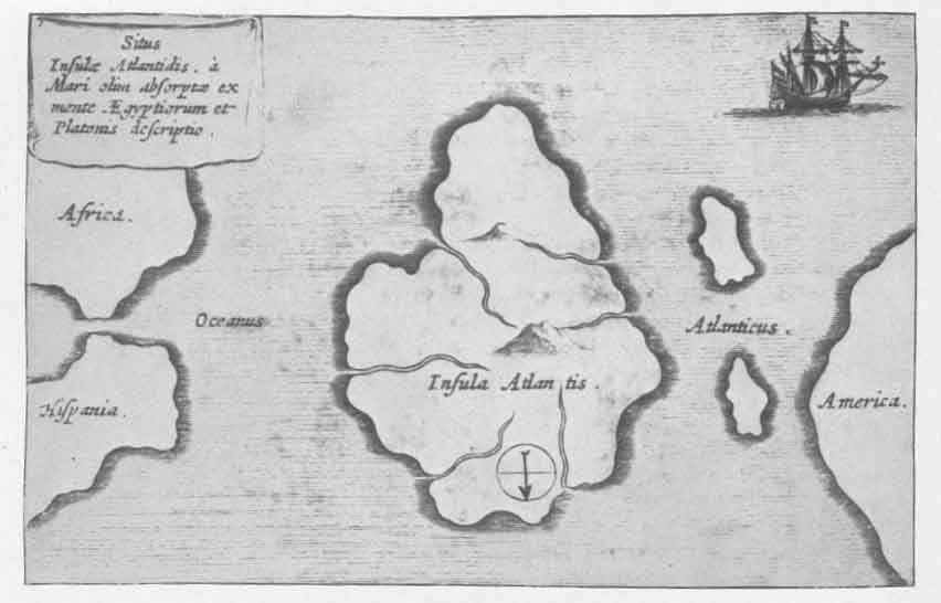
Every one has seen somewhere Kircher's drawing of the Island of Atlantis--this was the last remnant of the continent, which tradition says sank 12,000 years ago--but it is doubtful that any one has ever seen it reproduced as it appeared in his Mundus Subterraneus of 1678 (Plate XV).
[paragraph continues] It is always reversed, relettered, and made to conform to the right geography. The ship in the upper right-hand corner is turned bottom side up, and made to lie at anchor in the lower left-hand corner. Let the old mistake stand, if mistake it was--and mistake it was surely. Turning it upside down will put everything into right relation with modern geography. Only the ship will be wrong, like a mirage in the waters. Plate XVI is Kircher's accompanying illustration of "Ocean mountains," whose highest peaks may be island remnants of sunken continents, a little ground plan of the ocean floor.
Kircher, whose bold "guesses" on things he could not prove brought him less fame than blame, guessed again on the combined problems of the Deluge and lost continents, and in his Arca Noë, 1665, presented, in a world-map, a "conjectural geography of the Earth's translation after the Flood, from the opinions of various geographers, to which the author subscribes" (Plate XVII). This is a very odd map, by the way, and one evidently little known to modern geographers. Imagine a little German scholar, sitting in Rome under the shadow of St. Peter's during the Thirty Years' War, and guessing simply, not only at the form and extent of the then discovered but by no means explored Americas, and not only at the form and extent of the still unknown Arctic and Antarctic "continents," but also at the conformation and extent of the "ocean-mountains," and of the sunken antediluvian continents. To say he guessed wrong is to say a little less than nothing. This map represents more clearly than his little drawing of Atlantis, his then novel theory that the
Click to enlarge
PLATE XV Situation of the Island of Atlantis, according to the ideas of the ancient Egyptians and the description of Plato.
(From Mundus Subterraneus; Athanasius Kircher, 1678)
[paragraph continues] Lost Island had been situated west of Gibraltar, and that the Canaries and the Azores are to-day its only remnants. But what it really does, of course, is to send the conjectural Atlantean continent straight west into the Americas, and almost across them. Who knows? We are still guessing, and the Mayan excavations are furnishing golden material for further guesses. It may very well be that half a century from now this old "guess-map" of Kircher's will be even more interesting than it is to-day.
According to the beautiful maps of W. Scott-Elliot 1--Kircher's map may serve as a guide for Scott-Elliot's slightly different theory--the Atlantean continent extended from a point a few degrees east of Iceland to, approximately, the site of Rio de Janeiro in South America, and across the ocean to the African Gold Coast. It took in Texas, and the Gulf of Mexico, the southern and eastern States of America up to and including Labrador, and stretched across the Atlantic to the British Isles, embracing Scotland, Ireland, and part of northern England. Atlantis is, by this assumption, the parent land of America--a great continent surrounded by water at a time so far away as that in which the Sahara Desert was an ocean floor.