
Sacred Texts Atlantis Index Previous Next

Atlantis, the Antediluvian World, by Ignatius Donnelly, [1882], at sacred-texts.com
SUPPOSE we were to find in mid-Atlantic, in front of the Mediterranean, in the neighborhood of the Azores, the remains of an immense island, sunk beneath the sea--one thousand miles in width, and two or three thousand miles long--would it not go far to confirm the statement of Plato that, "beyond the strait where you place the Pillars of Hercules, there was an island larger than Asia (Minor) and Libya combined," called Atlantis? And suppose we found that the Azores were the mountain peaks of this drowned island, and were torn and rent by tremendous volcanic convulsions; while around them, descending into the sea, were found great strata of lava; and the whole face of the sunken land was covered for thousands of miles with volcanic débris, would we not be obliged to confess that these facts furnished strong corroborative proofs of the truth of Plato's statement, that "in one day and one fatal night there came mighty earthquakes and inundations which ingulfed that mighty people? Atlantis disappeared beneath the sea; and then that sea became inaccessible on account of the quantity of mud which the ingulfed island left in its place."
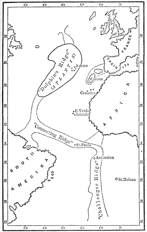
And all these things recent investigation has proved conclusively. Deep-sea soundings have been made by ships of different nations; the United States ship Dolphin, the German frigate Gazelle, and the British ships Hydra, Porcupine, and Challenger have mapped out the bottom of the Atlantic, and the result is the revelation of a great elevation, reaching from a point on the coast of the British Islands southwardly to the coast of South America, at Cape Orange, thence south-eastwardly
Click to enlarge
MAP OF ATLANTIS, WITH ITS ISLANDS AND CONNECTING RIDGES, FROM DEEP-SEA SOUNDINGS.
to the coast of Africa, and thence southwardly to Tristan d'Acunha. I give one map showing the profile of this elevation in the frontispiece, and another map, showing the outlines of the submerged land, on page 47. It rises about 9000 feet above the great Atlantic depths around it, and in the Azores, St. Paul's Rocks, Ascension, and Tristan d'Acunha it reaches the surface of the ocean.
Evidence that this elevation was once dry land is found in the fact that "the inequalities, the mountains and valleys of its surface, could never have been produced in accordance with any laws for the deposition of sediment, nor by submarine elevation; but, on the contrary, must have been carved by agencies acting above the water level." (Scientific American, July 28th, 1877.)
Mr. J. Starke Gardner, the eminent English geologist, is of the opinion that in the Eocene Period a great extension of land existed to the west of Cornwall. Referring to the location of the "Dolphin" and "Challenger" ridges, he asserts that "a great tract of land formerly existed where the sea now is, and that Cornwall, the Scilly and Channel Islands, Ireland and Brittany, are the remains of its highest summits." (Popular Science Review, July, 1878.)
Here, then, we have the backbone of the ancient continent which once occupied the whole of the Atlantic Ocean, and from whose washings Europe and America were constructed; the deepest parts of the ocean, 3500 fathoms deep, represent those portions which sunk first, to wit, the plains to the east and west of the central mountain range; some of the loftiest peaks of this range--the Azores, St. Paul's, Ascension, Tristan d'Acunba--are still above the ocean level; while the great body of Atlantis lies a few hundred fathoms beneath the sea. In these "connecting ridges" we see the pathway which once extended between the New World and the Old, and by means of which the plants and animals of one continent travelled to the other; and by the same avenues black men found their
way, as we will show hereafter, from Africa to America, and red men from America to Africa.
And, as I have shown, the same great law which gradually depressed the Atlantic continent, and raised the lands east and west of it, is still at work: the coast of Greenland, which may be regarded as the northern extremity of the Atlantic continent, is still sinking "so rapidly that ancient buildings on low rock-islands are now submerged, and the Greenlander has learned by experience never to build near the water's edge," ("North Amer. of Antiq.," p. 504.) The same subsidence is going on along the shore of South Carolina and Georgia, while the north of Europe and the Atlantic coast of South America are rising rapidly. Along the latter raised beaches, 1180 miles long and from 100 to 1300 feet high, have been traced.
When these connecting ridges extended from America to Europe and Africa, they shut off the flow of the tropical waters of the ocean to the north: there was then no "Gulf Stream;" the land-locked ocean that laved the shores of Northern Europe was then intensely cold; and the result was the Glacial Period. When the barriers of Atlantis sunk sufficiently to permit the natural expansion of the heated water of the tropics to the north, the ice and snow which covered Europe gradually disappeared; the Gulf Stream flowed around Atlantis, and it still retains the circular motion first imparted to it by the presence of that island.
The officers of the Challenger found the entire ridge of Atlantis covered with volcanic deposits; these are the subsided mud which, as Plato tells us, rendered the sea impassable after the destruction of the island.
It does not follow that, at the time Atlantis was finally ingulfed, the ridges connecting it with America and Africa rose above the water-level; these may have gradually subsided into the sea, or have gone down in cataclysms such as are described in the Central American books. The Atlantis of Plato may have been confined to the "Dolphin Ridge" of our map.
Click to enlarge
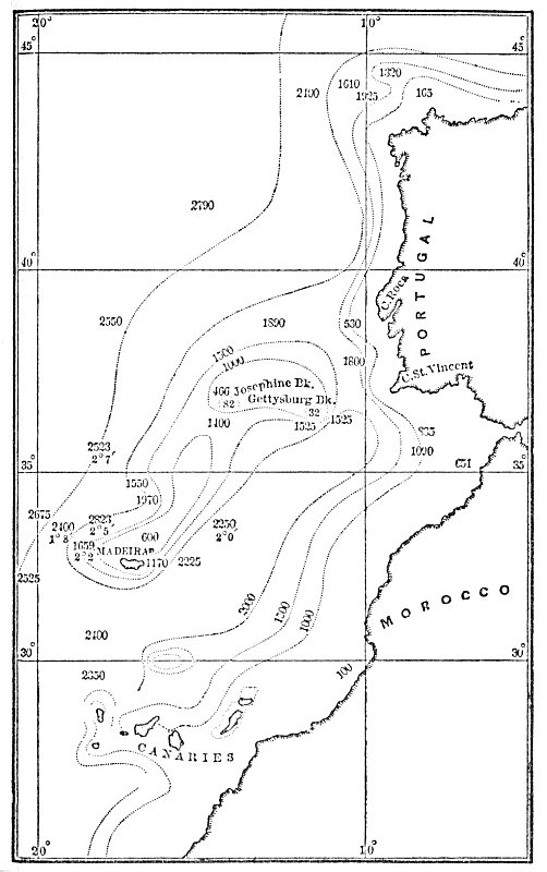
ANCIENT ISLANDS BETWEEN ATLANTIS AND THE MEDITERRANIAN, FROM DEEP-SEA SOUNINGS.
The United States sloop Gettysburg has also made some remarkable discoveries in a neighboring field. I quote from John James Wild (in Nature, March 1st, 1877, p. 377):
"The recently announced discovery by Commander Gorringe, of the United States sloop Gettysburg, of a bank of soundings bearing N. 85° W., and distant 130 miles from Cape St. Vincent, during the last voyage of the vessel across the Atlantic, taken in connection with previous soundings obtained in the same region of the North Atlantic, suggests the probable existence of a submarine ridge or plateau connecting the island of Madeira with the coast of Portugal, and the probable subaerial connection in prehistoric times of that island with the south-western extremity of Europe." . . . "These soundings reveal the existence of a channel of an average depth of from 2000 to 3000 fathoms, extending in a northeasterly direction from its entrance between Madeira and the Canary Islands toward Cape St. Vincent. . . . Commander Gorringe, when about 150 miles from the Strait of Gibraltar, found that the soundings decreased from 2700 fathoms to 1600 fathoms in the distance of a few miles. The subsequent soundings (five miles apart) gave 900, 500, 400, and 100 fathoms; and eventually a depth of 32 fathoms was obtained, in which the vessel anchored. The bottom was found to consist of live pink coral, and the position of the bank in lat. 36° 29' N., long. 11° 33' W."
The map on page 51 shows the position of these elevations. They must have been originally islands;--stepping-stones, as it were, between Atlantis and the coast of Europe.
Sir C. Wyville Thomson found that the specimens of the fauna of the coast of Brazil, brought up in his dredging-machine, are similar to those of the western coast of Southern Europe. This is accounted for by the connecting ridges reaching from Europe to South America.
A member of the Challenger staff, in a lecture delivered in London, soon after the termination of the expedition, gave it as his opinion that the great submarine plateau is the remains of "the lost Atlantis."