
Sacred Texts Legends and Sagas England Index Previous Next
Stonehenge and Other British Stone Monuments Astronomically Considered, by Norman Lockyer, [1906], at sacred-texts.com
OTHER circles to which I have given some attention are at Stanton Drew in Somerset. I regret to say that I have not as yet had an opportunity of visiting them. But a cursory inspection on the Ordnance map of the possible sight-lines from circle to circle, for there are three, suggested at once that we were dealing with the same problem as that worked out, if somewhat differently, at the Hurlers.
The three circles, two avenues leading from two of the circles towards the river, and some outstanding stones were most carefully surveyed by Mr. C. E. Dymond some years ago. He was good enough to. send me copies of his plans and levelling sections. I have not had the advantage of perusing his memoir, but I have studied the monuments as well as I could by means of the 25-inch Ordnance map. This, combined with an azimuth which Colonel Johnston, the Director-General of the Ordnance Survey, was kind enough to send me, should give me bearings within a degree.
I will begin by giving a short account of the stones which remain abridged from the convenient pamphlet prepared for the British Association meeting at Bristol in 1898 by Prof Lloyd Morgan.
The circles at Stanton Drew, though far less imposing than those of Avebury and Stonehenge, are thought to be more ancient than are the latter, for the roughhewn uprights and plinths of Stonehenge bear the marks of a higher and presumably later stage of mechanical development. Taken as a group, the Somersetshire circles, are in some respects more complex than their better known rivals in Wiltshire. There are three circles, from two of which "avenues" proceed for a short distance in a more or less easterly direction; there is a shattered but large dolmen—if we may so regard the set of stones called "the cove"; and there are outlying stones—the "quoit," and those in Middle Ham—which bear such relations to the circles as to suggest that they too formed parts of some general scheme of construction.
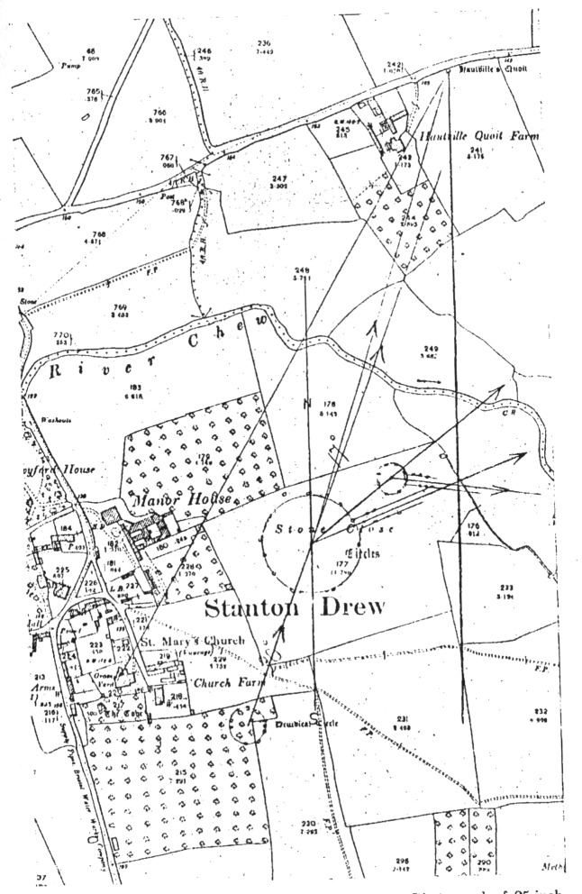
From the photograph of the Ordnance map (Fig. 47) it will be seen, as pointed out by Prof. Lloyd Morgan,
(1) That the centre of the great circle, that of the S.W. circle, and that of the quoits, are nearly in the same straight line.
(2) That the cove, the centre of the great circle, and that of the N.E. circle, are nearly in the same straight line.
The quoit, which, generally means the covering stone of a cromlech—"Hautville's Quoit," as it is named on the Ordnance map—looms large in Stanton Drew tradition; it is locally as much respected as the
circles themselves. It is pointed to most unmistakably by the fact that a line from it to the S. W. circle passes nearly through the centre of the great circle.
If the observation line, then, meant anything astronomically, it can only have had to do with the rising of a star far to the north, in a position far more northerly than the sun ever reaches.
The "quoit," lying in an orchard by the roadside, has nothing very impressive about its appearance—a recumbent mass of greyish sandstone; but it seems to be a brick in the Stanton Drew building. By some regarded as a sarsen block from Wiltshire, it is, in Prof. Lloyd Morgan's opinion, more probably derived from the Old Red Sandstone of Mendip. In any case it is not, geologically speaking, in situ; nor has it reached its present position by natural agency.
With regard to two of the megalithic circles, at first sight the constituent stones seem irregularly dotted about the field; but as we approach them the unevenly spaced stones group themselves.
The material of which the greater number of the rude blocks is composed is peculiar and worthy of careful examination. It is a much altered rock consisting, in most of the stones, of an extremely hard siliceous breccia with angular fragments embedded in a red or deep brown matrix, and with numerous cavities which give it a rough slaggy appearance. Many of these hollows are coated internally with a jasper-like material, the central cavity being lined with gleaming quartz-crystals.
The majority of the stones were probably brought from Harptree Ridge on Mendip, distant some six
Click to enlarge
Fig. 47.--The Circles and Avenues at Stanton Drew. Photograph of 25-inch Ordinance map, shewing approximate azimuths of sight-lines
miles. Weathered blocks of Triassic breccia, showing various stages of silicification, there lie on the surface and there probably lay the weathered monoliths which have been transported to Stanton Drew. It is important to note that they were erected unhewn and untouched by the tool. A few stones are of other, material—sandstone, like the "quoit," or oolite from Dundry.
In the great circle, of the visible stones some retain their erect position, others are recumbent, several are partially covered by accumulation of grass-grown soil. Others are completely buried, their position being revealed in dry seasons by the withering of the grass above them.
To the east of this circle a short avenue leads out, there being three visible stones and one buried block on the one hand, and two visible stones on the other. But one's attention is apt to be diverted from these to the very large and massive megaliths of the small N.E. circle. This is composed of eight weathered masses, one of which (if indeed it do not represent more than one), Prof. Lloyd Morgan tells us, is recumbent and shattered. From this circle, all the stones of which are of the siliceous breccia, a short avenue of small stones also opens out eastwards.
The third or S.W. circle lies at some little distance from the others, The average size of the stones is smaller than in either of the other circles, and not all are composed of the same material.
"The Cove," which has been variously regarded as a dolmen, a druidical chair of state, and a shelter for sacrificial fire, is close to the church.
The dimensions and numbers of the stones are as follow:
|
Great |
circle, |
diameter |
368 |
feet, |
30 |
stones. |
|
N.E. |
„ |
„ |
97 |
„ |
8 |
„ |
|
S.W. |
„ |
„ |
145 |
„ |
12 |
„ |
As I was not able to visit Stanton Drew when the significance of the northerly alignments struck me, I made an appeal to Prof. Lloyd Morgan, of whose pamphlet I have so largely made use, to obtain some theodolite, observations. As a result such observations have been made by himself and Mr. Morrow, from whom I have recently received a report with full permission to make use of it in this place.
The monuments are not easy to measure, as the centres of the circles are not readily determined, as so many of the stones are either absent, recumbent or buried.
In my rough reading of the Ordnance map given in Fig. 47, I thought I might be guided by taking centres, such that the avenues would be aligned on them as at Stonehenge. I had not then seen the Dartmoor avenues, which in some cases are not aligned on the centres. In this it is possible that I was wrong, as both Mr. Dymond's and Mr. Morrow's observations suggest that the avenues are really of the Dartmoor pattern. Mr. Morrow writes: "The centres of the circles are (to a certain small extent) a matter of choice, a difference of a few minutes may easily occur. In dealing with the avenues a larger discrepancy may occur. I have taken what, in my opinion, was the best centre line of each avenue and
thus determined its azimuth. But I believe that originally the southern line of stones forming each avenue was directed towards the centre of the corresponding circle, and that the avenue was then completed by the erection of a parallel line of stones. A difference of a few degrees may thus be accounted for in the azimuth supposed to have been originally marked out."
About Mr. Morrow's azimuths there can be no question. He writes:
“The instruments used were, first, a 6″ theodolite, and second, a 6″ transit theodolite. The final results were obtained with the latter. It cannot be reversed when measuring elevations. I tested it very carefully for the adjustments of (a) line of collimation at right angles to the horizontal axis, (b) horizontal axis perpendicular to vertical axis, and (c) line of collimation and spirit level parallel to each other. The instrument, was in first-rate order, the error in elevation, for example, being within that corresponding to a slope of 1 in 40,000; that is well within the limit of 20″ to which vertical angles can be read.
“The meridian was obtained by two different methods applied several times, the results agreeing very closely. Readings of azimuths and altitude of sun were taken between three and four hours after noon, corrected for semi-diameter, &c., and the true bearing obtained with the aid of the latitude and the declination given in Nautical Almanac (corrected for time).
“With regard to the elevations of the horizon, the existence of trees on or just below the sky-line renders readings to the nearest minute uncertain. In all cases
[paragraph continues] I have tried to give the most probable value, supposing the trees to be absent. In some places the heights will have altered slightly during recent years owing to the construction of railways.
"The values given are the means of observations. They are not corrected for height of instrument above ground, which might increase the angles by about 5 mins. Trees on the sky-line appear to make a difference of some 35 mins."
The azimuths as found by Mr. Morrow and myself are as under:
|
|
|
|
Height of horizon. (excluding trees). |
|
|
Morrow. |
Lockyer. |
Morrow. |
|
1 From centre of great circle to Hauteville's quoit |
N 17° 59´ E. |
17° |
2° 23´ |
|
From centre of great circle to N.E. circle |
53° 0´ |
51° |
1° 5´ |
|
Front centre of great circle along great circle avenue |
68° 43´ |
65° |
0° 38´ |
|
From centre of N.E. circle along N.E. circle avenue |
S. 83° 52´ E. |
79° |
1° 40´ |
|
From centre of S.W. circle to centre of great circle |
19° 51´ E. |
20° |
1° 44´ |
The azimuths to which I first direct attention are-these:
|
|
Az. |
|
Great circle to quoit |
N. 17° E |
|
S.W. circle to great circle |
N. 20° E. |
These azimuths indicate that at Stanton Drew as at
the Hurlers and elsewhere we are dealing with Arcturus as a clock-star. The facts are:
|
Az. |
N. Decln. |
Height of hills. |
Star. |
Date. |
|
N. 17° E. |
38° 59´ 0″ |
2° 23´ |
Arcturus |
1690 |
|
20° |
37° 26´ 50″ |
1° 44´ |
„ |
1410 |
One of the greatest differences between Mr. Morrow's local observation and my reading of the 25-inch Ordnance map occurs in the case of the direction of the avenue from the great circle. It may be suggested that the use of this avenue was to observe the May and August sunrises of the May year. If we take the sun's declination at 16° 20´ N., see p. 22, the azimuth should be about N. 64° E.; this is 1° from my value and 5° from that given by Mr. Morrow, but it must not be forgotten that the choice of a day in May and August slightly differing from the normal date might easily produce such a variation.
It seems probable that the great circle was one of the first erected, and the fact that, like Stonehenge, it had, an avenue, but that, unlike Stonehenge, the avenue was directed towards the May and not the June (solstitial) sunrise further, I think, suggests that the May worship was considered the most important and was the first provided for.
There is reason for supposing that the great circle was at all events built before the S. W. one. The great circle is situated at a lower level than the S.W. one. The angular elevation of the hills over which Arcturus rose would appear, therefore, to be higher from the great than from the S.W. circle. Arcturus has been reducing its declination for centuries in consequence of the precessional movement. It would
therefore rise gradually in a greater azimuth, that is, nearer the east. An observer in the centre of the great circle, to follow this more easterly rising over the quoit, would have to change his position gradually to the westward. But there was another way. The original direction could be nearly maintained if the observation were made at a higher level near the original line, as then the relative elevation of the rising-place would be reduced.
This is what possibly was done, and this indeed may be the vera causa of the building of the S.W. circle.
This view of the possible function of the, "quoit" is, of course, strengthened by the fact that we find traces of high northerly alignment in other stone circles. I have already shown that there are such alignments in Cornwall.
The "quoit" is nearly on a level with the great circle, while the hills rise behind it. It has been suggested that it would have been more useful on the top of the hill, but this suggestion cannot be accepted for a moment if it were used in the way I. have indicated. On a dark night it would have been invisible, and it also would have prevented the observation of star-rise if it were truly aligned. Being comparatively near the circle it could easily have been illuminated at the critical time, and thus have anticipated the bright line,; micrometer of .more modern times.
So far I have found no obvious use for the avenue attached to the N.E. circle. The conditions are:
|
Az. |
Height of Hills. |
Dec. | ||
|
Morrow. |
Lockyer. |
Morrow. |
Morrow. |
Lockyer. |
|
S. 83° 52´ E. |
S. 79´ E.´ |
1° 40´ |
3° 62´ 30″ S. |
5° 49.´ 30″ S. |
With regard to this N.E. circle, in relation to the large circle, the data are as follows:
|
Az. |
Height of Hills. |
Dec. N. | ||
|
Morrow. |
Lockyer. |
Morrow. |
Morrow. |
Lockyer. |
|
N. 53° E. |
N. 51° E. |
1° 5´ |
22° 43´ 50″ |
23° 48´ 46″ |
[paragraph continues] As Mr. Morrow states, the choice of centre of the circle may alter the azimuth obtained by as much as "a few degrees," but the value obtained from the Ordnance map is, definitely, N. 51° E., and with the height of hills determined by Mr. Morrow this would suggest, that the N.E. circle was really erected to provide the alignment, from the centre of the great circle, or from the Cove, to the summer solstitial sun, about the year 870 B.C., Stockwell's values for the obliquity being taken. This result is the more striking as it gives a date for the substitution of the June for the May worship at Stanton Drew, which is in full accordance with that obtained for the similar change at Stenness.
There is other evidence, to which I attach importance, as it deals with a method and policy found in many temple fields in Egypt, that of blocking the alignment of an older star- or sun-cult, which the astronomer-priests replaced by their own. The stones. of the avenue of the solstitial N.E. circle I expect once blocked the May sunrise line from the great circle; judging from the Ordnance map, and remembering the number of stones that have disappeared, this is probable if not certain.
If this were so, then the N.E. circle was the last to be erected, and this suggestion is strengthened by Mr. Lewis's statement that it is the most perfect of the three.
Prof. Lloyd Morgan concludes his interesting account
of which I have made so much use with the following remarks:
"In what order the circles were constructed we do not know. Whether the small, N.E. circle with its more massive megaliths preceded or succeeded the great circle with its more numerous but, on the average, less massive stones, is a matter of mere conjecture. They may have been contemporaneous: but it is more likely that so large a work took a long time in execution; nor does the unity of plan of the final product preclude a gradual process of development. Finally as to the purpose of the erection, and its hidden astronomical, mythological, or social meaning (if it have one), we are once more at the mercy of more or less plausible conjecture. There stand the circles in a quiet Somersetshire valley, silent memorials of a race concerning whose modes of life, of labour, and of thought we can but speculate."
It is to be hoped that before the monument has disappeared like so many of its fellows, some student with more knowledge and time to devote to the inquiry than myself will endeavour to answer more of the questions raised by it.
173:1 With regard to these values Mr. Morrow writes: "At present Hauteville's quoit is not visible from the centre of great circle. If the stone were erect, however, and any intervening trees and walls removed, the top of the stone would no doubt be within view. The Hauteville quoit line is thus rather a difficult one to obtain with accuracy, but the azimuth given should be correct to the nearest minute."