
Sacred Texts Legends and Sagas England Index Previous Next
Stonehenge and Other British Stone Monuments Astronomically Considered, by Norman Lockyer, [1906], at sacred-texts.com
I WROTE a good deal in Nature 1 on sun and star temples in 1891, and Mr. Lewis the next year expressed the opinion that the British stone monuments, or some of them, were sun and star temples.
Mr. Magnus Spence, of Deerness, in Orkney, published a pamphlet, "Standing Stones and Maeshowe of Stenness," 2 in 1894; it is a reprint of an article in the Scottish Review, October, 1893, showing that the stones were set up for solar worship. Mr. Cursiter, F.S.A., of Kirkwall, in a letter to me dated March 15, 1894, a letter suggested by my "Dawn of Astronomy," which appeared in that year, and in which the articles which had been published in Nature in 1891, had been expanded, directed my attention to the pamphlet.
I began the consideration of the Stenness circles and alignments in 1901, but other pressing calls on my time then caused me to break. off the inquiry. Quite recently it occurred: to me that a complete study of the Stenness circles might throw light on the question of an earlier
Click to enlarge
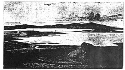
FIG. 38.—Maeshowe, in the foreground, and the Stones of Stenness. From “Notice of Runic Inscriptions,” by James Farrer, M.P. (1862).
[paragraph continues] Stonehenge, so I have gone over the old papers, plotting the results on the Ordnance map.
Now that the inquiry is as complete as I can make it without spending some time in Orkney with a theodolite, I will begin my reference to other circles besides Stonehenge by stating the conclusions at which I have arrived with regard to the stones of Stenness.
In the first place I may state that although many of the alignments to which Mr. Spence refers in his pamphlet on Maeshowe prove to be very different from those he supposed and drew on the map which accompanies his paper, the main point of his contention is amply confirmed.
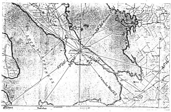
I give a copy of the Ordnance map showing the true orientation of these and of other sight-lines I have made out.
The alignments on which Mr. Spence chiefly depended were two, one running from the stone circle past the entrance of Maeshowe to the place of sunrise at Hallowe’en (November 1), another from the same circle by the Barnhouse standing stone to the mid-winter sunrise at the solstice.
Although the map gives these sight-lines, I shall show that they had not the use Mr. Spence attributes to them; but still observations of the sun were provided for on the days in question, and the circles and outstanding stones were undoubtedly set up to guide astronomical observations relating to the different times of the year. Of course, as I have shown elsewhere; such, astronomical observations were always associated with religious celebrations of one kind or another, as the astronomer and the priest were one.
Click to enlarge
FIG. 39.—Copy of Ordinance Map showing chief sight-lines from the stones of Stenness.
I shall not refer to all the sight-lines indicated, but deal only with those which I have without local knowledge been able to test and justify by means of the 25-inch Ordnance map.
Not only does calculation prove the worship of the May and June years, but I think the facts now before us really go to show that in Orkney the May year was the first established, and that the solstitial (June) year, came afterwards, and this was one of the chief questions I had in view.
I will begin with, the May year. I have already shown, p. 22, that the half-way time between an equinox and a solstice is when the sun's centre has a declination approximately 16° 20´ N. or S. In Orkney, with the latitude of 59°, assuming a sea horizon, the approximate amplitude of sunrise or sunset is 33° 6´; the corresponding azimuth being 56° 54´.
Now the most interesting and best defined line near this azimuth on the Ordnance map is the one stretching S.E. from the centre of the Stenness circle to the Barnstone, with an azimuth of 57° 15´. The line contains between the two points I have named another stone, the Watchstone, 18½ feet high, in the precise alignment; and from the statements made and measures given it is to be inferred that a still more famous and perforated stone, the "Stone of Odin," demolished seventy years since, was also in the same line within the extremities named.
If we may accept this we learn something about perforated stones, and can understand most of the folk lore associated with them, and few have more connected with them than the one at Stenness. I
suggest that the perforation, which was in this case 5 feet from the ground, was used by the astronomer; priest to view the sunrise in November over the Barnhouse stone in one direction, and the sunset in May over the circle in the other. I hope to be able to return to this question subsequently.
There is another echo of this fundamental line; that joining the Ring of Bookan and the Stones of Via has the same azimuth and doubtless served the same purpose for the May year.
But this line, giving us the May sunset and November sunrise, not the December solstitial sunrise as Mr. Spence shows it, is not the only orientation connected with the May year at the stones of Stenness. The November sunset is provided for by a sight-line from the circle to a stone across the Loch of Stenness with an azimuth of S. 53° 30´ W.
To apply the table, given on p. 120, to the solstitial risings and settings at Stenness, and the sight-lines which I have plotted on the map, it will be seen that the table shows us that the lines marked
|
|
|
S. 41° 0´ E. |
|
N. 41° 16´ E. |
|
S. 36° 30´ W. |
are solstitial lines; to get exact agreement with the table the heights of the hills must be found and allowed for.
I have roughly determined this height from the 1-inch map in the case of the Barnstone-Maeshowe .alignment. On the N.E. horizon are the Burrien Hills, four miles away, 600 feet high at the sunrise place, gradually ascending to the E. vertical angle = 1° 36´ 30″. The
near alignment is on and over the centre of Maeshowe. Colonel Johnston, the Director-General of the Ordnance Survey, has informed me that the true azimuth of this bearing is N. 41° 16´ E., and in all probability it represents the place of sunrise as seen from the Barnstone when Maeshowe was erected. What is most required in Orkney now is that some one with a good 6-inch theodolite should observe the sun's place of rising and the angular height of the hills at the next summer solstice in order to determine the date of the erection of Maeshowe. Mr. Spence and others made an attempt to determine this value with a sextant in 1899, but not from the Barnstone.
In the absence of this observation we may use the diagram given on p. 121. With the height of hill previously given the sun should rise according to calculation at about the azimuth N. 41 50´ E.
The difference between the new and old azimuth then, on the assumption that az. N. 41° 16´ E. really represents an observation over Maeshowe, gives us the difference of date.
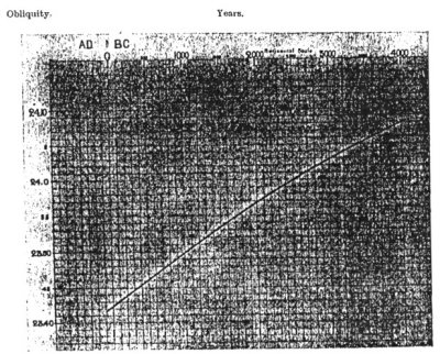
Treating these figures then as we have done in the case of Stonehenge in. Chapter VII, the result is as follows. The Barnhouse-Maeshowe line was established about 700 B.C., when the obliquity had in value of 23° 48´ according to Stockwell's tables. (Fig. 40.)
I confess the late date does not surprise me. The masonry of Maeshowe differs widely from that of other similar structures in that the sides of the gallery and chamber, instead of being composed of upright stones, are built in regular courses.
I do not believe that the Maeshowe structure was
built to observe a winter sunrise twenty days from the solstice, nor can I think it was set up at midsummer by someone who had only dealt with a high sun and a sea horizon, and imagined that the sunrise and sunset points were exactly opposite to each other. It was a priest's house, and the alignment of the passage to the
Click to enlarge
FIG. 40.—Variation of the Obliquity of the Ecliptic, 100 A.D.-4000 B.C.
(Stockwell's Values.)
[paragraph continues] Barnstone was for the exchange of signals, probably by lights in Maeshowe itself.
The Ordnance maps give no indication of stones, &c., by which the direction of the midsummer setting or the midwinter rising and setting might have been indicated from either the Maeshowe or the Barnstone.
To sum up the solar alignments from the circle.
We have the May sunrise marked by the top of Burrien Hill, from 600 to 700 feet high, Az. 59° 30´.
We have the November sunset marked by a standing stone on the other side of the Loch of Stenness, Az. 53° 30´.
June rising, Line from Barn stone over Maeshowe tumulus.
December rising, tumulus (Az. 41°) on Ward Bill. December setting, tumulus Onston 36° 30'.
It is not. a little remarkable that the summer solstice rising and the winter solstice rising and setting seem to leave been provided for at the Stenness circle by alignment on the centres of tumuli, two of them, across the Loch, one the Onston tumulus to the S.W. (Az. 36° 30´), the other tumulus being on Ward Hill to the S.E., Az. 41° (rough measurement).
If the Maeshowe tumulus was a structure erected at the time I have suggested to use the Barnstone for the summer solstice rising; then these two other tumuli, to deal with the winter solstice at Stenness circle, may have been built at the same time. All these provided for a new cult.
There are also tumuli near the line (which cannot be exactly determined because the heights of the hills are unknown) of the summer solstice setting; none was required for the sunrise at this date, as the line passes over the highest point of Hindera fiold, a natural tumulus more than 500 feet high, and on that account a triangulation station.
Another argument in favour of the tumuli being additions to the original design is that the place of the November setting from the Stenness circle is marked,
not by a tumulus, but by a standing stone. As this stone, near Deepdale, and the tumulus at Onston are only about 1200 yards apart, the suggestion may be made that under certain unknown conditions and possibly in later times tumuli in some cases replaced stones as collimation marks.
With regard to the clock-star, it is to be feared that the stones in the N.E. quadrant as viewed from the circle which might have given us a clue have been removed. As the latitude of Stenness is N. 59°, some star with a less declination than N. 31° would have been chosen, assuming that the sky-line towards the N. point is not very high.
123:1 See especially Nature, July 2, 1891, p. 201.
123:2 Gardner: Paisley and London.