
Sacred Texts Legends and Sagas England Index Previous Next
Stonehenge and Other British Stone Monuments Astronomically Considered, by Norman Lockyer, [1906], at sacred-texts.com
AFTER Mr. Penrose, by his admirable observations in Greece, had shown that the orientation theory accounted as satisfactorily for the directions in which the chief temples in Greece had been built as I had shown it did for some in Egypt, it seemed important to apply the same methods of inquiry with all available accuracy to some example, at all events, of the various stone circles in Britain which have so far escaped destruction. Many attempts had been previously made to secure data, but the instruments and methods employed did not seem to be sufficient.
Much time has, indeed, been lost in the investigation of a great many of these circles, for the reason that in many cases the relations of the monuments to the chief points of the horizon have not been considered; and when they were, the observations were made only with reference to the magnetic north, which is different at different places, and besides is always varying; few indeed have tried to get at the astronomical conditions of the problem.
The first, I think, was Mr. Jonathan Otley, who in 1849 showed the "Orientation" of the Keswick Circle "according to the solar meridian," giving true solar bearings throughout the year.
I wrote a good deal in Nature 1 on sun and star temples in 1891, and Mr. Lewis the next year expressed the opinion that the British Stone Monuments, or some of them, were sun and star temples.
Mr. Magnus Spence of Deerness in Orkney published a pamphlet, "Standing Stones and Maeshowe of Stenness, 2" in 1894; it is a reprint of an article in the Scottish Review, Oct. 1893. Mr. Cursiter, F.S.A., of Kirkwall, in a letter to me dated 15 March 1894, a letter suggested by my Dawn of Astronomy which appeared in that year and in which the articles which had appeared in Nature in 1891 had been expanded, drew my attention to the pamphlet; the observations had no pretension to scientific accuracy, and although some of the sight-lines were incorrectly shown in an accompanying map, May year and solstitial alignments were indicated.
So far as I know, there has never been a complete inquiry into the stone circles in Britain, but Mr. Lewis, who has paid great attention to these matters, has dealt in a general manner with them (Archaeological Journal, vol. xlix. p. 136), and has further described (Journal Anthropological Institute, n.s., iii., 1900) the observations made by him of stone circles in various parts of Scotland. From an examination of the latter he concludes
that they may be divided into different types, each of which has its centre in a different locality. The types are—(1) the Western Scottish type, consisting of a rather irregular single ring or sometimes of two concentric rings (2) the Inverness type, consisting of a more regular ring of better-shaped stones, surrounding a tumulus with a retaining wall, containing a built-up chamber and passage leading to it, or a kist without a passage; (3) the Aberdeen type, consisting of a similar ring with the addition of a so-called "altar-stone" and usually having traces of a tumulus and kist in the middle. In addition to these three types of circles, there are in Britain generally what Mr. Lewis calls sun and star circles, with their alignments of stones, and apparently proportioned measurements. He has shown that there is a great preponderance of outlying stones and hill-tops lying between the circles and the N.E. quarter of the horizon. From what has been stated in Chapter III with regard to the nightly observations of stars it will be gathered that these may have been used for this purpose.
The following list gives some of the bearings of outlying stones and other circles from the centres of the named circles:—
|
Roll-rich, Oxon.—Kingstone |
N. 27° |
E. |
|
Stripple Stones, Cornwall—Bastion on bank |
N. 26 |
E. |
|
Long Meg, Cumberland—Small circle |
N. 27 |
E. |
|
The Hurlers, Cornwall—Two outlying circles |
N. 13-16 |
E. |
|
Trippet Stones—Leaze circle |
N. 11 |
E. |
If these alignments mean anything they must of course refer to the rising of stars, as the position on the horizon is outside the sun's path.
The many circles in Cornwall have been dealt with by Mr. Lukis in a volume published by the Society of Antiquaries in 1895. 1 A carefully prepared list of circles will be found in Mr. Windle's recently published work entitled "Remains of the Prehistoric Age in England."
It may be useful here to state, with regard to megalithic remains generally, that they may be classed as follows; some details will be discussed later on.
(a) Circles: These may be single, double, or multiple, and either concentric or not.
(b) Menhirs, large single stones, used to mark sight-lines from circles.
(c) Alignments, i.e., lines of stones in single, double, or in many parallel lines. If these alignments are short they are termed avenues.
(d) Holed-stones, doubtless used for observing sight-lines, sometimes over a circle.
(e) Coves. A term applied by Dr. Stukeley and others to what they considered shrines: formed by three upright stones, thus leaving one side open. I take them to be partially protected observing places. There are well-marked examples at Avebury, Stanton Drew and Kit's Coity House.
(f) Cromlechs. This term generally means a grouping of upright stones; it is applied to irregular circles in Brittany. It also applies to a stone or stones raised on the summits of three or more pillar stones forming the end and sides of an irregular vault generally open at one end ("Dolmens of Ireland," Borlase, p. 429).
[paragraph continues] The top stone is called in S.W. England a "quoit." Cromlechs in most cases have been covered by barrows or cairns.
(g) Dolmens, from Dol Men, a table stone. These consist of stones, resting on two or more upright stones forming a more or less complete chamber, some of which are of great length. I note the following subdivisions: "Dolmen à galerie" having an entrance way of sufficient height, and "Galgal," similar but smaller. In the "Dolmen â l’allée couverte" there is a covered passage way to the centre. It is a more elaborate cove. For the relation between cromlechs and dolmens, see Borlase (loc. cit. and p. 424 et seq.).
With regard to dolmens, I give the following quotation from Mr. Penrose (Nature, vol. lxiv., September 12, 1901):—
“Near Locmariaquer in the estuary named Rivière d’Auray, there is an island named Gavr’ Inis, or Goat Island, which contains a good specimen of the kind of dolmen which has been named 'Galgal.'
“At the entrance our attention is at once arrested by the profusion of tracery which covers the walls. From the entrance to the wall facing us the distance is between 50 and 60 feet. The square chamber to which the gallery leads is composed of two huge slabs, the sides of the room and gallery being composed of upright stones, about a dozen on each side. The mystic lines and hieroglyphics similar to those above mentioned appear to have a decorative character.
"An interesting feature of Gavr’ Inis is its remarkable resemblance to the New Grange tumulus at Meath.
[paragraph continues] In construction there is again a strong resemblance to Maas-Howe, in the island of Orkney. There is also some resemblance in smaller details."
While we generally have circles in Britain without, or with small, alignments; in Brittany we have alignments without circles, some of them being on an enormous scale; 1 thus at Menec (the place of stones) we have eleven lines of menhirs, terminating towards the west in a cromlech, and, notwithstanding that great numbers have been converted to other uses, 1169 menhirs still remain, some reaching as much as 18 feet in height.
The alignments of Kermario (the place of the dead) contain 989 menhirs in ten lines. Those of Kerlescant (the place of burning), which beginning with eleven rows are afterwards increased to thirteen, contain altogether 579 stones and thirty-nine in the cromlech, with some additional stones. The adoration paid these stones yielded very slowly to Christianity, In the church history of Brittany the Cultus Lapidum was denounced in 658 A.D.
Many of the fallen menhirs in these alignments have been restored to their upright position by the French Government. Some of them may have been overturned in compliance with the decree of 658 A.D. above referred to. Several of the loftier menhirs are surmounted by crosses of stone or iron.
Both circles and alignments are associated with holidays and the lighting of fires on certain days of the
year. This custom has remained more general in Brittany than in Britain. At Mount St. Michael, near Carnac, the custom still prevails of lighting a large bonfire on its summit at the time of the summer solstice; others, kindled on prominent eminences for a distance of twenty or thirty miles, round, reply to it. These fires are locally called "Tan Heol," and also by a later use, Tan St. Jean. In Scotland there was a similar custom in the first week in May under the name of Bel Tan, or Baal's Fire; the synonym for summer used by Sir Walter Scott in the "Lady of the Lake":—
At Kerlescant the winter solstice is celebrated by a holiday, whilst Menec greets the summer solstice, and Kermario the equinoxes, with festivals. Concerning these fires and the associated customs Mr. Frazer's "Golden Bough" is a perfect mine of information and should be consulted. It may simply be said here that the May and November, and June and December fires seen to be the most ancient. It is stated that the Balder bale fires on Mayday Eve were recognised by the primitive race, and I shall prove this in the sequel when British customs are referred to. On the introduction of Christianity the various customs were either transferred to or reorganised in association with church festivals but as some of these, such as Easter, are movable feasts, it is difficult to follow the dates.
Regarding both circles and alignments in the light of the orientation theory, we may consider simple
circles with a central stone as a collection of sight-lines from the central stone to one or more of the outer ones, or the interval between any two; indicating the place of the rise or setting of either the sun or a star on some particular day of the year, which day, in the case of the sun, will be a new year's day.
Alignments, on the other hand, will play the same part as the sight-lines in the circles.
Sometimes the sight-line may be indicated by a menhir outside, and even at a considerable distance from, the circle; later on tumuli replaced menhirs.
The dolmens have, I am convinced, been in many cases not graves originally, but darkened observing places whence to observe along a sight-line; this would be best done by means of an allée couverte, the predecessor of the darkened naos at Stonehenge, shielded by its covered trilithons.
In order to obtain some measurements to test the orientation theory in Britain, I found that Stonehenge is the ancient monument in this country which lends itself to accurate theodolite work better than any other. Mr. Spence's excellent work on astronomical lines at Stenness, where the stones, till some years ago at all events, have been more respected than further south, suggested a beginning there, but the distance from London made it impossible.
Avebury and Stanton Drew are well known to a great many archæologists; there are also other very wonderful stone circles near Keswick and in other parts of England; but unfortunately it is very much more difficult, to get astronomical data from these
ancient monuments than it is in the case of Stonehenge, one reason being that Stonehenge itself lies high, and the horizon round it in all directions is pretty nearly the same height, so that the important question of the heights of the hills along the sightline—a matter which is fundamental from an astronomical point of view, although it has been neglected so far as I can make out, by most who have made observations on these ancient monuments—is quite a simple one at Stonehenge. Hence it was much easier to determine a date there than by working at any of the other ancient remains to which I have referred.
In orientation generally—such orientation as has been dealt with by Mr. Penrose and myself in Egypt and in Greece—the question frequently was a change in direction in the axis of a temple, or the laying down of the axis of a temple, by means of observations of stars. Unfortunately for us as archæologists, not as astronomers, the changes of position of the stars, owing to certain causes, chiefly the precessional movement, are very considerable; so that if a temple pointed to a star in one year, in two or three hundred years it would no longer point to the same star, but to another.
These star observations were requisite in order to warn the priests about an hour before sunrise so that they might prepare for the morning sacrifice which always took place at the first appearance of the sun. Hence the morning star to be visible in the dawn must be a bright one, and the further north or south of the sun's rising place it rose, the more easily it would be seen. Some stars so chosen rose not far
from the north point of the horizon. The alignments with small azimuths referred to in the British circles (p. 36) I believe to be connected with the Egyptian and Greek practice.
Acting on a very old tradition, some people from Salisbury and other surrounding places go to observe the sunrise on the longest day of the year at Stonehenge. We therefore are perfectly justified in assuming that it was a solar temple used for observation in the height of midsummer. But at dawn in midsummer in these latitudes the sky is so bright, that it is not easy to see stars even if we get up in the morning to look for them; stars, therefore, were not in question, so that some other principle had to be adopted, and that was to point the temple directly to the position on the horizon at which the sun rose on that particular day of the year, and no other.
Now, if there were no change in the position of the sun, that, of course, would go on for ever and ever; but, fortunately for archaeologists, there is a slight change in the position of the sun, as there is in the case of a star, but for a different reason; the planes of the ecliptic and of the equator undergo a slight change in the angle included between them. So far as we know, that angle has been gradually getting less for many thousands of years, so that; in the case of Stonehenge, if we wish to determine the date, having no stars to help us, the only thing that we can hope to get any information from is the very slow change of this angle; that, therefore, was the special point which Mr. Penrose and I were anxious to study at Stonehenge, for the reason that we seemed in a position

Click to enlarge
FIG. 8.—The original tooling of the stone protected from the action of the weather.
to do it there more conveniently than anywhere else in Britain.
But while the astronomical conditions are better at
[paragraph continues] Stonehenge than elsewhere; the ruined state of the monument makes accurate measurements very difficult.
Great age and the action of weather are responsible for much havoc, so that very many of the stones are now recumbent, as will be gathered from an article
Click to enlarge
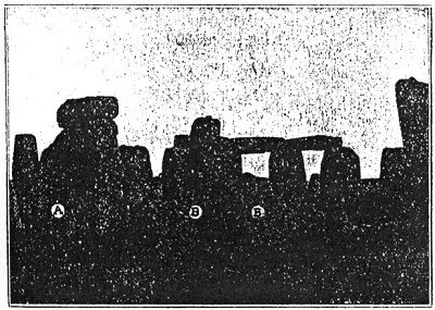
FIG. 9.—View of Stonehenge from the west. A stone which fell in 1909; BB, stones which fell in 1797. (Reproduced from an article on the fallen stones by Mr. Lewis in Man.)
by Mr. Lewis, who described the condition of the monument in 1901, in Man.
Professor Gowland in his excavations at Stonehenge, to which I shall refer in the sequel, found the original tooled surface near the bottom of one of the large sarsens which had been protected from the action of the weather by having been buried in the ground. It enables us to, imagine the appearance of the monument as it left the hands of the builders (Fig. 8).
But the real destructive agent has been man himself; savages could not have played more havoc with
Click to enlarge
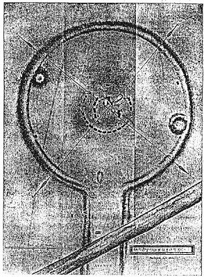
FIG. 10.—Copy of Hoare's plan of 1810, showing the unbroken Vallum and its relation with the Avenue.
the monument than the English who have visited it at different times for different purposes. It is said the
fall of one great stone was caused in 1620 by some excavations, but this has been doubted; the fall of another in 1797 was caused by gipsies digging a hole in which to shelter, and boil their kettle; many of the stones have been used for building walls and bridges; masses weighing from 56 lb. downwards have been broken off by hammers or cracked off as a result of fires lighted by excursionists.
It appears that the temenos wall or vallum, which is shown complete in Hoare's plan of 1810, is now broken down in many places by vehicles indiscriminately driven over it. Indeed, its original importance has now become so obliterated that many do not notice it as part of the structure—that, in fact, it bears the same relation to the interior stone circle as the nave of St. Paul's does to the Lady Chapel (Fig. 10).
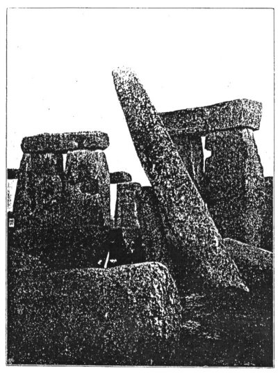
It is within the knowledge of all interested in archæology that not long ago Sir Edmund Antrobus, the owner of Stonehenge, advised by the famous Wiltshire local society, the Society for the Protection of Ancient Buildings, and the Society of Antiquaries, enclosed the monument in order to preserve it from further wanton destruction, and—a first step in the way of restoration—with the skilled assistance of Prof. Gowland and Messrs. Carruthers, Detmar Blow and Stallybrass, set upright the most important menhir, which threatened to fall or else break off at one of the cracks. This. menhir, the so-called "leaning stone," once formed one of the uprights of the trilithon the fall of the other member of which is stated by Mr. Lewis to have occurred before 1574. The latter, broken in two pieces,
Click to enlarge
FIG. 11.—The Leaning Stone in 1901.
and the supported impost, now lie prostrate across the altar stone.
This piece of work was carried out with consummate
skill and care, and most important conclusions; as we shall see in a subsequent chapter, were derived from the minute inquiry into the conditions revealed in the excavations which were necessary for the proper conduct of the work.
Let us hope that we have heard the last of the work of devastators, and even that, before long, some of the other larger stones, now inclined; or prostrate, may be set upright.
Since Sir Edmund Antrobus, the present owner, has acted on the advice of the societies I have named to enclose the monument, with a view to guard it: from destruction and desecration, he has been assailed on all sides. It is not a little surprising that the "unclimbable wire fence" recommended by the societies in question (the Bishop of Bristol being the president of the Wiltshire society, at the time) is by some regarded as a suggestion that the property is not national, the fact being that the nation has not bought the property, and that, it has been private property for centuries, and treated in the way we have seen.
Let us hope also that before long the gaps in the vallum may be filled up. These, as I have already stated, take away from the meaning of an important part of one of the most imposing monuments of the world. In the meantime it comforting to know that, thanks to what Sir Edmund Antrobus has done, no more stones will be stolen, or broken by sledge-hammers; that fires; that excavations such as were apparently the prime cause of the disastrous fall of one of the majestic trilithons in 1797; that litter, broken bottles
and the like, with which too many British sightseers mark their progress, besides much indecent desecration, are things of the past.
If Stonehenge had been built in Italy, or France, or Germany, it would have been in charge of the State long ago.
I now pass from the monument itself to a reference to some of the traditions and historical statements concerning it.
Those who are interested in these matters should thank the Wiltshire Archæological and Natural History Society, which is to be warmly congratulated on its persistent and admirable efforts to do all in its power to enable the whole nation to learn about the venerable monuments of antiquity which it has practically taken under its scientific charge. It has published two most important volumes 1 dealing specially with Stonehenge, including both its traditions and history.
With regard to Mr. Long's memoir, it may be stated that it includes important extracts from notices of Stonehenge from the time of Henry of Huntingdon (twelfth century) to Hoare (1812), and that all extant information is given touching on the questions by whom the stones were erected, whence they came, and' what was the object of the structure.
From Mr. Harrison's more recently published bibliography, no reference to Stonehenge by any ancient author, no letter to the Times for the last twenty
years dealing with any question touching the monuments, seems to be omitted.
It is very sad to read, both in Mr. Longs volume and the bibliography, of the devastation which has been allowed to go on for so many years and of the various forms it has taken.
As almost the whole of the notes which follow deal with the assumption of Stonehenge having been a solar temple, a short reference to the earliest statements concerning this view is desirable; and, again, as the approximate date arrived at by Mr. Penrose and myself in 1901 is an early one, a few words may be added indicating the presence in Britain at that time of a race of men capable of designing and executing such work. I quote from the paper communicated by Mr. Penrose and myself to the Royal Society:—
“As to the first point, Diodorus Siculus (ii., 47, ed. Didot, p. 116) has preserved a statement of Hecatæus in which Stonehenge alone can by any probability be referred to.
“‘We think that no one will consider it foreign to our subject to say a word respecting the Hyperboreans.
"'Amongst the writers who have occupied themselves with the mythology of the ancients, Hecatæus and some others tell us that opposite the land of the Celts. [ἐν τοῖς ἀντιπέραν τῆς Κελτικῆς τόποις] there exists in the Ocean an island not smaller than Sicily, and which, situated under the constellation of The Bear, is inhabited by the Hyperboreans; so called because they live beyond the point from which the North wind. blows. . . . If one may believe the same mythology, Latona was born in
this island, and for that reason the inhabitants honour Apollo more than any other deity. A sacred enclosure [νῆσον] is dedicated to him in the island, as well as a magnificent circular temple adorned with many rich offerings. . . . The Hyperboreans are in general very friendly to the Greeks.'"
“The Hecatæus above referred to was probably Hecatæus of Abdera, in Thrace, fourth century B.C.; a friend of Alexander the Great. This Hecatæus is said to have written a history of the Hyperboreans that it was Hecatæus of Miletus, an historian of the sixth century B.C., is less likely.
“As to the second point, although we cannot go so far back in evidence of the power and civilisation of the Britons, there is an argument of some value to be drawn from the fine character of the coinage issued by British kings early in the second century B.C., and from the statement of Julius Cæsar ('De Bello Gallico,' vi., c. 14) that in the schools of the Druids the subjects taught included the movements of the stars, the size of the earth, and the nature of things (multa præterea de sideribus et eorum motu, de mundi magnitudine, de rerum natura, de deorum immortalium vi ac potestate disputant et juventuti tradunt).
"Studies of such a character seem quite consistent with, and to demand, a long antecedent period of civilisation."
Henry of Huntingdon is the first English writer to refer to Stonehenge, which he calls Stanenges. Geoffrey of Monmouth (1138) and Giraldus Cambrensis come next.
In 1771, Dr. John Smith, in a work entitled "Choir Gawr, the Grand Orrery of the Ancient Druids, called
[paragraph continues] Stonehenge, Astronomically Explained, and, proved to be a Temple for Observing the, Motions of the Heavenly Bodies," wrote as follows:—
"From many and repeated visits, I conceived it to be an astronomical temple; and from what I could recollect to have read of it, no author had as yet investigated its uses. Without, an instrument or any assistance whatever, but White's 'Ephemeris,' I began my survey. I suspected the stone called The Friar's Heel to be the index that would disclose the uses of this structure; not was I deceived. This stone stands in a right line with the centre of the temple, pointing to the north-east. I first drew a circle round the vallum of the ditch and divided it into 360 equal parts; and then a right line through, the body of the temple to the Friar's Heel; at the intersection of these lines I reckoned the sun's greatest amplitude at the summer solstice, in this latitude, to be about 60 degrees, and fixed the eastern points accordingly. Pursuing this plan, I soon discovered the uses of all the detached stones, as well as those that formed the body of the temple."
With regard to this "Choir Gawr," translated Chorea Gigantum, Leland's opinion, is quoted,(Long, p. 51) that we should read Choir vawr, the equivalent of which is Chorea nobilis or magna. 1
In spite of Inigo Jones's (1600) dictum that Stonehenge was of Roman origin, Stukeley came to the conclusion in 1723 that the Druids were responsible for
its building; and Halley, who visited it in 1720—probably with Stukeley—concluded from the weathering of the stones that it was at least 3000 years old; if he only had taken his theodolite with him, how much his interest in the monument would have been increased!
35:1 See especially Nature, July 2, 1891 p. 201.
35:2 Gardner, Paisley and London.
37:1 "The Prehistoric Stone Monuments of the British Isles—Cornwall."
39:1 "The French Stonehenge: An Account of the Principal Megalithic Remains in the Morbihan Archipelago." By T. Cato Worsfold, F.R.Hist.S., F.R.S.I. (London: Bemrose and Sons, Ltd.)
50:1 The Wiltshire Archaeological and Natural History Magazine: "Stonehenge and its Barrows." By William Long, M.A., F.S.A. 1876. The Wiltshire Archaeological and Natural History Magazine: "Stonehenge Bibliography Number." By W. Jerome Harrison. 1902.
53:1 Mr. Morien Morgan informs me that Cor y Gawres is correct, and means Choir of the Giantess: Cariadwen, the Welsh Neith, Nyth (Nydd).