Sacred Texts Pacific Index Previous Next
Te Pito Te Henua, or Easter Island, by William J. Thompson, [1891], at sacred-texts.com
By Paymaster WILLIAM J. THOMPSON, U. S. Navy.
The honor of the discovery of Easter Island is contested by several of the earlier voyagers in the Pacific. Spanish writers claim that the island was sighted by Mendana in 1566, but the account is by no means authenticated, and the records preserved are not sufficiently accurate to determine the exact track sailed over by that ancient mariner. Captain Davis is credited by Capt. William Dampier with being the first to sight the island, and Lionel Wafer, who cruised with that bold navigator, on board of the Batchelor's Delight, gives the following account of the discovery in the year 1687:
Bound to the southward, in latitude 12 degrees 30 minutes and about 150 leagues off the coast, experienced a shock of earthquake, that was afterwards found to correspond with the destruction of Callao by earthquake. Having recovered from our fright we kept on to the southward. We steered south-and-by-east-half-easterly, until we came to latitude 27 degrees 20 minutes south, when about two hours before day we fell in with a small low, sandy island and heard a great roaring noise, like that of the sea beating upon the shore, right ahead of the ship. Whereupon the sailors, fearing to fall foul upon the shore before day, desired the captain to put the ship about, and to stand off until the day appeared; to which the captain gave his consent. So we plied off till day and then stood in again with the land, which proved to be a small flat island, without any guard of rocks. We stood in within a quarter of a mile of the shore and could see it plainly, for it was a clear morning, not fogy or hazy. To the westward about 12 leagues, by judgment, we saw a range of high land, which we took to be islands, for there were several partitions in the prospect.
This land seemed to reach about 14 or 16 leagues in a range, and there came great flocks of fowls. I and many more of our men would have made this land and have gone ashore on it, but the captain would not permit us. The small island bears from Copiapó almost due east 500 leagues, and from the Galapagos, under the line, 600 leagues.
Unfortunately, none of the voyagers on board of the Batchelor's Delight were permitted to land upon this unknown island, nor is mention made in the narratives of monoliths or unusual structures that might have been observed from the short distance in which it is claimed they approached the shore. The apparent inaccuracy in the description of the appearance of the land may have been due, to the peculiar bearing of the vessel, but it gives foundation to the claim of Admiral Roggeveen,
that Davis's island was not identical with the one discovered by him on April 7, 1722, and named Easter Island in commemoration of the day upon which the land was sighted. Roggeveen says:
When we approached nearer the land we saw distinctly from a short distance that the description of the sandy and low island did not accord in the least with our discovery. Furthermore, it could not be the same land which the aforesaid voyagers claim to have seen stretching 14 to 16 leagues in front of them, and near the highland which Dampier judged to be the coast-line of the unknown south. That Easter Island can not be the sandy island described by Davis is clear, because that was small and low, while on the contrary Easter Island is high and towers above the sea, having also two elevations rising above the level part. It would not be possible to mistake, even at the dry season of the year, the grass and verdure that covers the hill-sides for barren sand. After the Dutch custom of the day, the admiral assembled the commanders of the three vessels composing his fleet--the Arend, the African Galley, and the Thienhoven--in council to pass formal resolutions claiming the discovery of the land. The proceedings of the assembly state that on Easter day land was sighted about 9 miles distant, of moderate height, and containing an area of about 6 Dutch miles. The weather being calm the vessels were not able to secure an anchorage near the land until the next day, The island was found to be destitute of trees, but with a fertile soil producing bananas, potatoes, and sugar-cane of extraordinary thickness. It was unanimously agreed that both from the difference in the location as well as the appearance of the land seen by Davis, the fact was established beyond doubt that the island just discovered could not be the same. These proceedings, being drawn up, were formally signed by Jacob Roggeveen, Jan Koster, Cornelius Bonman, and Roelof Rosendaal. After sailing from Easter Island the vessels spent a number of days in it search for the low sandy island described by Davis, but not with success.
The unreliable Behrens mentions in the "Two Years' Voyage" the discovery of Easter Island by Roggeveen on the day celebrated as the resurrection of the Lord (April 6, 1722), in latitude 27 degrees south and longitude 268 degrees west.
Capt. F. W. Beechey, R. N., commanding H. M. S. Blossom (November, 1825), referring to the discovery of Easter Island, finds the credit due to Davis, giving the following reasons for the conclusions drawn:
Had such an island been in existence, answering to the description of that seen by Davis, geographers would not have been long in reconciling their opinions on the subject of his discovery, as in all probability they would have waived their objections to its distance from Copiapó in consideration of its identity. The subject of the supposed discovery has been often discussed; and when the data are so unsatisfactory as to allow one party to choose the islands of Felix and Ambrose for the land in question, and the other Easter Island, two places nearly 1,600 miles apart, they are not likely to be speedily reconciled unless two islands exactly answering the description given by Davis, and situated in the proper latitude, shall be found.
Without entering upon a question which presents so many difficulties, I shall merely observe that, considering the rapid current that exists in the vicinity of the Galapagos, and extends, though with diminished force, throughout the trade-wind, the error in Davis's reckoning is not more than might have happened to any dull sailing vessel circumstanced as he was. In a short run from Juan Fernandez to Easter Island, Behrens, who was with Roggeveen, was drifted 318 geographical miles to the westward of his supposed situation. H. M. S. Blossom in passing over the same ground experienced a set of 270 miles in the short space of 18 days. M. La Pérouse on his arrival at Sandwich Islands from Concepcion, touching at Easter Island on his way,
found a similar error of 300 miles in file course of that passage. It is fair to presume that Davis was longer in crossing from the Galapagos to Easter Island than either of those vessels or, at least, than the Blossom; and it is consequently but reasonable to allow him it greater error, particularly as the first part of his route was through a much stronger current. But taking the error in the Blossom's reckoning as a fair amount and applying it to the distance given by Wafer, there will remain only 204 miles unaccounted for between it and the real position of Easter Island, which, from the foregoing considerations, added to the manner in which reckonings were formerly kept, does not appear to me to exceed the limit that that might reasonably be ascribed to those causes.
M. La Pérouse was of the opinion that the islands of Felix and Ambrose were those under discussion, and in order to reconcile their distance from Capiapó with that given by Wafer, has imputed to him a mistake of a figure in his text, without considering that it would have been next to impossible for Davis to have pursued a direct course from the Galapagos to those islands (especially at the season in which his voyage was made), but on the contrary that he would be compelled to make a circuit which would have brought him much nearer to Easter Island, and that Davis acquainted Dampier with the situation of his discovery, which agreed with that contained in Wafer's account.
The alteration of a figure, it must be admitted, is rather arbitrary, as it has nothing to support it but the circumstance of the number of islands being the same. A mistake certainly might have occurred, but in the admission of it either party may claim it as an advantage by interpreting the presumed error in a way which would support his own opinion.
Cook and Pérouse differ in a very trifling degree from each other, and also from us, in the geographical position of Easter Island. The longitude is, by Cook, 109 degrees 46 minutes 20 seconds, and deducting 18 minutes 30 seconds, in consequence of certain corrections made at Fetegu Island, leaves 109 degrees, 27 minutes, 50 seconds west. That by Pérouse, allowing the longitude of Concepcion to be 72 degrees 56 minutes 30 seconds west, is 109 degrees 32 minutes 10 seconds west, and our own is 109 degrees 24 minutes 54 seconds west.
Admitting that the land was first sighted by Davis, the fact is beyond question that the Dutchmen under Roggeveen were the first Europeans to land on the island. From the unfortunate termination of his cruise, and the suppression of his official journal for so many years, but little has been handed down to us in the way of description of the island as it then appeared.
The Spaniards sighted the island in 1770, and gave it the name of St. Carlos. Captain Cook called it Easter Island in March, 1774, and sent all expedition on shore, but his log affords little in regard to its, general appearance beyond the fact that it was parched and desolate, and of no value as a place of refreshment.
M. Bernizet, geographical engineer, who visited the island in April, 1786, with the La Pérouse expedition, describes its appearance with care, and after the lapse of it century his notes are found to be sufficiently accurate for ordinary purposes.
Amasa Delano, Kotzebue, Lisiansky, and many other voyagers made brief calls at the island, and their journals afford little information. The recent French, Spanish, and English charts are sufficiently accurate in the main features, but some of the coast lines were evidently established from running surveys, and are incorrect. During the stay of the
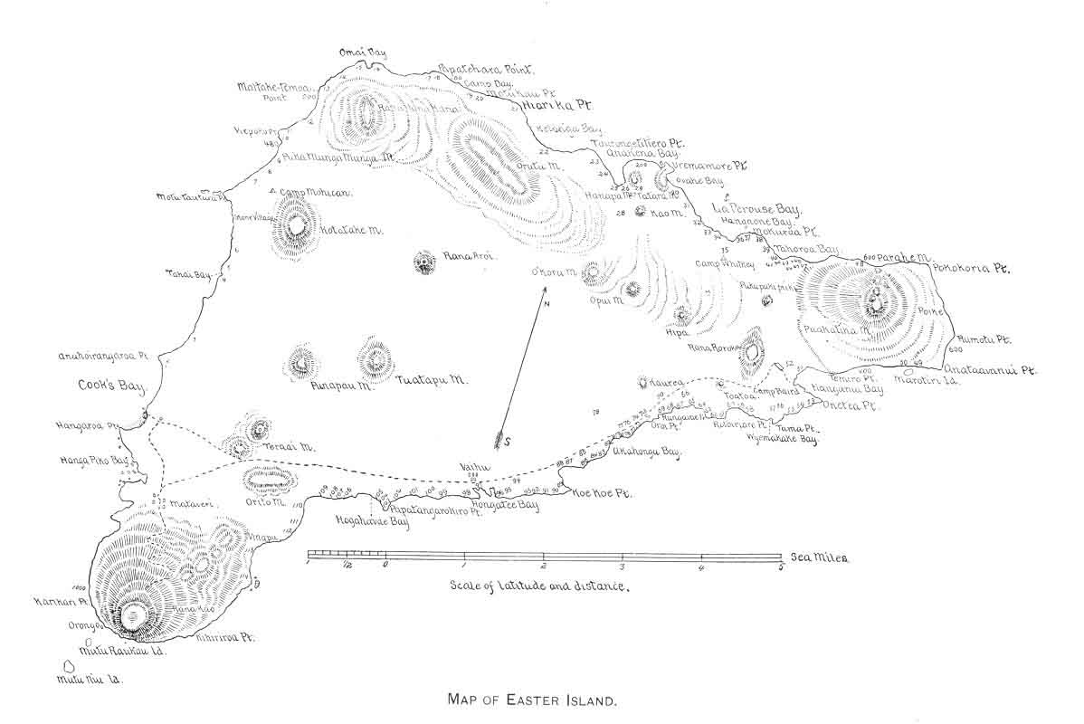
Mohican Lieut. F. M. Symonds, with Naval Cadet C. M. McCormick as assistant, made a careful survey of the island, and their chart, herewith appended, will be found accurate and replete with interest. (Plate XII.)