Sacred Texts Earth Mysteries Index Previous Next
IN THE STUBBORN RESISTANCE immediately manifested by a few who would have rejoiced had the evidences produced by the employment of the Rectilineator been favorable to the Copernican theory we find history repeating itself. Because of this we publish the following quotation from the pen of a recognized scientist, which reveals the character of the opposition to the facts of demonstration and observation in its true light. Fallacy is rooted and grounded in the very heart of humanity, and will not abandon its hold without a struggle.
I learned, as my first great lesson in the inquiry into obscure fields of knowledge, never to accept the disbelief of great men or their accusations of imposture or of imbecility, as of any weight when opposed to the repeated observation of facts by other men admittedly sane and honest. The whole history of science shows us that whenever educated and scientific men of any age have denied the facts of other investigators on a priori grounds of absurdity, the deniers have always been wrong.--Prof. A. Russel Wallace, the Eminent Naturalist.
For the benefit of the reader we here recall the idiotic opposition to the facts. of the discovery, by the noted Harvey, of the circulation of the blood in the human system. Although he produced the evidence,--made ocular demonstrations of the flow of the blood through the arteries and veins of the human body, the physicians and anatomists of the old schools refused to
investigate. Today, there is not a man that can be found to deny the circulation of the life fluid through the arterial and venous systems.
When the telescope was invented and began to reveal the movement of satellites about the planets, the facts observed by Galileo and others were stubbornly denied by the astronomers of the Ptolemaic system; and for years Galileo succeeded in inducing but few to witness the phenomena through the telescope.
One scientist who had more zeal, prejudice, and jealousy than knowledge and wisdom, wrote a dissertation on the telescope, attempting to show how astigmatisms could be produced in the lenses, and the lenses made to revolve in such a way as to give the appearance of the satellites revolving around the planet Jupiter. That man lived and died without having made a single astronomical observation by means of the telescope, What did he know about the telescope? The sequel proves that he knew nothing; yet he denied that the objects that were seen, were possible to be seen.
The earth's concavity is considered as an absurdity, and the long line of demonstrations of the same, the mere result of deception and fraud. What do our critics know about the facts we have observed? Upon what reasonable ground can the evidences we present be disputed by those who have never undertaken the lines of experimentation we have projected? The opposition to our work today is as unreasonable, absurd, and idiotic as that manifested against the work of Harvey and Galileo.
We persistently proclaim the facts we have observed and obtained; they are as persistently denied by a few who have never ventured near the surface of
water to test its contour. We have surveyed a line by means of a mechanical apparatus, the results of which are as easily (?) explained away by a few who have never seen the apparatus, and who know nothing about its capabilities or methods of use, as the moons of Jupiter were explained by those who had never observed their motions through the telescope. These so called explanations of the results of our survey we purpose to overthrow.
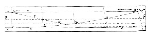
We have surveyed a line upon the Gulf coast of Florida. The measurements were such as to demonstrate conclusively the concave arc of the earth's curvature upon which the survey was made, and only the direction of its curvature, but also its ratio. In this survey we found a definite ratio of approach of the earth's surface to meet the rectiline extended from an altitude of 10 feet above the water level. The line was extended into the water's surface at a distance of about four miles from the beginning of the survey, as shown in the diagram accompanying this paragraph.
XY represent the concave arc over 4 miles in length; AB, the air line, A, the beginning, ten feet above the water, and B, the point of extension into the water; N is north, S, south; 1, 2, 3, 4, the mile stations; ab represent the external tangent parallel to the air line, showing the ratio of curvation of the
earth's surface for each mile of the survey, while cd represents a line referred to later in the article.
The ratio of the concave curvature was in proportion to the square of the distance; at the end of the first mile the distance between the air line and the water's surface was eight inches less than at beginning, because the earth in this distance had curvated upward eight inches; the second mile, about two feet and eight inches; third mile, six feet, while at the end of the fourth mile the line extended into the Gulf.
In the diagram, the lines of perpendiculars extending from the air line to the arc at 0, 1, 2, 3, 4, decrease in length in precisely the same proportion that the earth curvates concavely. Not only was the proper ratio found to exist at the end of four miles, but also at the end of every eighth of a mile from the beginning of the survey.
Let each reader capable of making a mathematical calculation of the ratio of curvature of a concave sphere 25,000 miles in circumference, test this ratio and the results obtained by the survey, and it will be found that such ratio cannot be obtained by the extension of a right line upon any other than a concave surface; the geometrical principles involved will not admit of it.
We confront two classes of objections to the character of the Geodetic work upon the coast of the Gulf of Mexico. From several sources it is claimed that the Rectilineator was not sufficiently accurate to extend a straight line; while from others comes the accusation that we purposely inclined the first section at the starting point so as to extend the line into the water at a
distance of four miles; from others, that the first section of the apparatus was not accurately leveled, but inclined toward the earth by mistake. We suppose these two classes of objections seem satisfactory to the minds expressing them.
We knew the objection would be urged that the apparatus was not accurate, and therefore took extra precautions, not only that such objections might be overthrown, but also to insure the accuracy required for such work; we did not devote four weeks to making the apparatus accurate for nothing.
The method employed to insure further accuracy was by making the apparatus neutralize its own inaccuracies by reversal or turning-over of each section at every alternate adjustment.
This process would correct any error arising from any inaccuracy of the brass-facings--for whatever error in the line would result from a single cross-arm being more or less than .005 of an inch out of right angle, would be corrected when that section should be reversed, as every mechanic well knows.
A source of inaccuracy is also attributed to the contraction and expansion of the material of which the apparatus is constructed. Those who make this objection have never seen the apparatus, and consequently cannot appreciate the fact that the plan of its construction obviates the effect of whatever contraction or expansion occurred.
Besides, there are no sources of error or inaccuracy--those of adjustment, settling, vibration from the wind, or change of temperature, that could conspire to produce a deviation of the air line always in same direction; check up all the errors that occur, as
is done by all surveyors, and the value of the "elements of chance" is found to reside in the fact that the deviations are finally neutralized.
It is supposed that settling played an important part in the descent of the line surveyed; if so, why should the line descend .15 of an inch for the first eighth of a mile, and 6 inches for the eighth between the 19th and 20th tide stakes? If settling produced the descent, this would be manifest by returning over the same line. We returned over the same line for a distance of ⅜ of a mile, to ascertain if there would be any deviation.
The fact that the horizontal axis of the apparatus projected the line on the return survey to the same points on the record stakes indicating the air line in the forward survey, is proof of the fact that the factors of settling, if any existed, were absolutely neutralized, for they did not swerve the apparatus from a true and directed rectiline course. Let those who make such objections explain how the exact and definite ratio was obtained, if we did not extend a rectiline from the beginning of the survey.
We now come to the examination of the charge that we purposely inclined the first section so as to permit of extension of the line into the water in four miles. Our burden at the present time is not that we failed to produce the evidences that the earth is con-cave, but to get such minds to see the utter absurdity of such objections. The fact that these objections contradict each other, is conclusive proof that both classes of objections are made without a foundation of conclusion, and are simply subterfuges with which
to evade the evidences afforded through the accurate survey.
Suppose that we did purposely incline the first section out of level, what would be the result? The charge involves the admission of three things,--very necessary factors in the work of extending a rectline. First, that our mathematics was exact--necessarily so, to calculate the angle of inclination; second, that we were capable of making some absolute measurements of angles in the adjustment of the first section of the apparatus; and third, that the apparatus, in order to extend a line from the inclined position of the first section into the water at a distance agreed (?) upon before the work began, would have to be perfect and capable of extending a straight line, for with what else than a perfect apparatus and accurate measurements of angles could we strike the water at the distance desired from a given inclination of the first section from an absolute level?
In order for the charge to be true, we would have to extend an absolutely straight line, involving just the kind of adjustments and minute measurements that the other class of minds say is impossible. We know that the first section was level, having applied two of the finest levels obtainable. We made no mistake--the accuracy of our line depended upon getting the first section in the absolutely correct position.
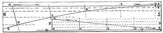
We will examine the charge in another light--in the light of geometrical principles, and will endeavor to illustrate our exposition of this charge and objection in the two diagrams in the following cut: Let XY represent the convex arc; AB the air line, beginning
at an altitude 10 feet 1 above the water, and inclined out of level so as to strike the water in four miles; N is north, S, south; 1, 2, 3, 4 indicate mile stations along the line of survey.
Now contrast the ratio of approach of the line to the water's surface that we have exhibited in the cut illustrating the line extended over the concave arc. In the first diagram, the line began parallel with the
water's surface, and ended obliquely to it. In this, the line begins at a definite angle from the horizontal, and ends coincidental with or parallel to the horizontal at B.
The ratio of approach of the line to the water's surface would be just the reverse to that really obtained. As for instance, beginning ten feet above the water, at the end of the first mile the line, according to the basis of the charge, would be four feet nearer the water's surface than at the beginning.
The ratio of approach of the line to the water's surface would be more rapid at the beginning of the line than at the ending, and the ratio of divergence of the line from the end of the line to the beginning would be in proportion to the square of the distance from
the end of the line; whereas in fact, in the survey of -the line at Naples, Fla., the ratio of convergence of the air line and the water's surface was less at the beginning of the line and greater at the ending.
If the air line had really descended at the ratio of four feet for the first mile, and so on in proportion, the line would have extended into the surface at a distance of 1¾ miles from the beginning of the line, and the angle of inclination from the horizontal would have been enormous.
If the earth were a plane, the result of inclining the first section of the Rectilineator so as to extend the line into the water in four miles would be an even ratio of descent of the line, as represented in the diagram below the convex arc in the above cut, in accordance with the principle of convergence of two straight lines.
XY would represent the water line; AB the air line as per charge; N is north, S is south; 1, 2, 3, 4, the mile stations. The approach of the line to the water for the first mile would have been 2½ feet; for the second mile, 2½ feet; and the same for the third and the fourth. The air line would sustain the same obliquity to the horizontal throughout the line of survey.
On the convex arc, the deviation of the horizontal axis of the apparatus would be greatest at the beginning of the line, and horizontal at the end. How was it? The line showed no perceptible deviation from the horizontal until near the end of the first eighth of a mile, and increased continually as the line progressed, until at the end of 2⅜ miles the obliquity of the air line to the horizontal was sufficient to extend the visual line from that point to the surface of the Gulf, below the horizon.
The above replies to the objections will be conclusive to those who will consider and comprehend the facts. It would be impossible to satisfy a man who doubted the accuracy of the multiplication table, until he came to a knowledge of some simple principles of mathematics. We do not expect to reach those who will not or cannot reason; their minds will have to be changed by the turn in the tide of popular favor from the old to the new system.
But it seems strange to us that--in the face of the facts obtained; in view of the fact that no such direct means have ever been applied by the old-school scientists; in view of the fact that they admit that all the so called evidences of the earth's convexity are only cumulative and circumstantial; and in view of the fact that those who criticise our work were not brave enough to face the issue and participate in the experiments performed by the Geodetic Staff--the direct and absolute evidences we have produced should be rejected by any mind capable of realizing the geometrical principles involved in simple right angles.
Corroborative of the demonstration of the earth's concavity by means of accurate survey, we have the long line of evidences obtained by other means,--tests of the surface of water on canals, lakes, and seas--tests and experiments which can be repeated upon any body of water to the satisfaction of the skeptical.
The facts we have observed and the line we have surveyed demonstrating the earth's true form, are susceptible of test. We challenge contradiction; but our challenge will have to be answered upon the field of contest, to which we dare the scientific critics, in the many lines of experimentation through which we have obtained the facts we announce to the world.
157:1 Really, to conform to the fact that the air line extended Into the water in four miles at an angle, with the horizon 1½ miles beyond the end of the chord, the altitude of the starting point, on the convex earth as per charge, would have to be 18 feet and 8 inches, instead of 10 feet! For the sake of simple illustration, we have represented the line as terminating at the horizon, and consequently parallel to the water.